Grasbroek

Map of the municipality Heerlen, showing the neighbourhood Grasbroek in red, which is part of the quarter Schandelen-Grasbroek in light red.
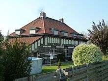
Typical house of the neighbourhood at Grasbroek 5-7, marked as national monument number 21223
Grasbroek is a neighbourhood and former mining colony in the municipality Heerlen, Netherlands. The neighbourhood was built to serve the mine Oranje-Nassau I.
Grasbroek houses the Patronaatsgebouw (Jos Wielders (1883–1949)), build in 1920 it is one of the earliest examples of Amsterdam School outside Amsterdam. Besides being in a state of disrepair all almost all original elements remain.[1] Currently it is being restored, restoringcost around 3,500,000 euros [2]
References
- ↑ "Archived copy" (PDF). Archived from the original (PDF) on 2007-04-05. Retrieved 2006-06-01. website
- ↑ "Archived copy". Archived from the original on 2007-06-21. Retrieved 2006-06-01. website
Coordinates: 50°53′49″N 5°58′33″E / 50.897050°N 5.975844°E
This article is issued from
Wikipedia.
The text is licensed under Creative Commons - Attribution - Sharealike.
Additional terms may apply for the media files.