Granite Mountains (California)
| Granite Mountains | |
|---|---|
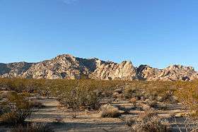 Late afternoon view from Kelbaker Road | |
| Highest point | |
| Elevation | 1,238 m (4,062 ft) |
| Geography | |
 Location of Granite Mountains in California [1] | |
| Country | United States |
| State | California |
| Region | Mojave Desert |
| District | San Bernardino County |
| Range coordinates | 35°30′48.882″N 116°44′18.121″W / 35.51357833°N 116.73836694°WCoordinates: 35°30′48.882″N 116°44′18.121″W / 35.51357833°N 116.73836694°W |
| Topo map | USGS Leach Lake |
The Granite Mountains is a small mountain range in San Bernardino County, California, USA, located in the Mojave Desert. They are in the Mojave National Preserve, in the National Park Service system.
Geography
The Granite Mountains are north of Interstate 40 and historic Route 66. The Providence Mountains are adjacent to the northeast. The Bristol Mountains are directly to the west, the Old Woman Mountains are to the southeast, and Pisgah Crater and the Bullion Mountains are to the southwest. The Mountains lie east of the small community of Kelso, northeast of Ludlow, and north of Amboy.
The range stretches from Granite Pass (34°48′44″N 115°36′37″W / 34.81222°N 115.61028°W) to Budweiser Wash (34°49′16″N 115°45′32″W / 34.82111°N 115.75889°W).
Geology
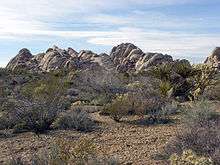
Some of the more striking rock formations in the Mojave National Preserve lie in the Granite Mountains. These granitic rocks have eroded into unusual rounded shapes that include spires, perched boulders, and curved cliff faces.
Granitic rocks represent the roots of ancient continental-margin volcanic systems. Most of the granitic rock in the Mojave Desert is late Mesozoic in age (80 to 180 million years old). The granites formed at depth within a volcanically active mountain range comparable in geologic setting to the Andes chain in South America.
The granitoids formed by the slow cooling and solidification of molten magma bodies that developed above sinking slabs of oceanic crust overridden by the edge of the continent. At least 55 or 60 million years elapsed between the crystallization of the last Mesozoic magma bodies and deposition of the youngest-preserved overlying strata.
Several springs exist in the Granite Mountains, though they may not flow year round.
References
- ↑ "Granite Mountains". Geographic Names Information System. United States Geological Survey. Retrieved 2009-05-03.
- America's Volcanic Past - Mojave National Preserve (USGS PD source)
| Wikimedia Commons has media related to Granite Mountains (California). |