Granite, Oklahoma
| Granite, Oklahoma | |
|---|---|
| Town | |
 Location of Granite, Oklahoma | |
| Coordinates: 34°57′45″N 99°22′53″W / 34.96250°N 99.38139°WCoordinates: 34°57′45″N 99°22′53″W / 34.96250°N 99.38139°W | |
| Country | United States |
| State | Oklahoma |
| County | Greer |
| Area | |
| • Total | 3.2 sq mi (8.4 km2) |
| • Land | 3.2 sq mi (8.4 km2) |
| • Water | 0.0 sq mi (0.0 km2) |
| Elevation | 1,614 ft (492 m) |
| Population (2010) | |
| • Total | 2,065 |
| • Density | 638/sq mi (246.5/km2) |
| Time zone | UTC-6 (Central (CST)) |
| • Summer (DST) | UTC-5 (CDT) |
| ZIP code | 73547 |
| Area code(s) | 580 |
| FIPS code | 40-30950[1] |
| GNIS feature ID | 1093311[2] |
| Website |
townofgranite |
Granite is a town in Greer County, Oklahoma, United States. The population was 2,065 at the 2010 census,[3] up from 1,844 at the 2000 census.
Geography
Granite is located in eastern Greer County at 34°57′45″N 99°22′53″W / 34.96250°N 99.38139°W (34.962367, -99.381356).[4] State Highways 6 and 9 intersect at the southern end of town; Highway 6 leads north 32 miles (51 km) to Elk City and south 23 miles (37 km) to Altus, while Highway 9 leads east 17 miles (27 km) to Hobart and west then south 13 miles (21 km) to Mangum.
Lake Altus on the North Fork Red River is 2 miles (3 km) east of the center of town. Headquarters Mountain, elevation 1,980 feet (600 m), rises 350 feet (110 m) directly above the north side of town.
According to the United States Census Bureau, the town has a total area of 3.2 square miles (8.4 km2), all land.[3]
Demographics
| Historical population | |||
|---|---|---|---|
| Census | Pop. | %± | |
| 1910 | 1,229 | — | |
| 1920 | 912 | −25.8% | |
| 1930 | 1,341 | 47.0% | |
| 1940 | 1,058 | −21.1% | |
| 1950 | 1,096 | 3.6% | |
| 1960 | 952 | −13.1% | |
| 1970 | 1,808 | 89.9% | |
| 1980 | 1,617 | −10.6% | |
| 1990 | 1,844 | 14.0% | |
| 2000 | 1,844 | 0.0% | |
| 2010 | 2,065 | 12.0% | |
| Est. 2015 | 2,031 | [5] | −1.6% |
| U.S. Decennial Census[6] | |||
As of the census[1] of 2000, there were 1,844 people, 443 households, and 283 families residing in the town. The population density was 1,166.3 people per square mile (450.6/km²). There were 533 housing units at an average density of 337.1 per square mile (130.2/km²). The racial makeup of the town was 69.47% White, 16.97% African American, 4.93% Native American, 0.38% Asian, 3.85% from other races, and 4.39% from two or more races. Hispanic or Latino of any race were 7.16% of the population.
There were 443 households out of which 27.1% had children under the age of 18 living with them, 48.8% were married couples living together, 10.4% had a female householder with no husband present, and 36.1% were non-families. 33.9% of all households were made up of individuals and 18.1% had someone living alone who was 65 years of age or older. The average household size was 2.26 and the average family size was 2.88.
In the town, the population was spread out with 13.7% under the age of 18, 12.6% from 18 to 24, 43.2% from 25 to 44, 18.3% from 45 to 64, and 12.2% who were 65 years of age or older. The median age was 36 years. For every 100 females, there were 259.5 males. For every 100 females age 18 and over, there were 304.8 males.
The median income for a household in the town was $25,438, and the median income for a family was $30,703. Males had a median income of $23,125 versus $20,368 for females. The per capita income for the town was $12,599. About 13.1% of families and 17.5% of the population were below the poverty line, including 23.0% of those under age 18 and 12.3% of those age 65 or over.
Local business
Situated at the foot of the Wichita Mountains, Granite is home to significant mining operations. Quarries such as Willis Granite Products extract native red granite for use in headstones, memorials and signs throughout the United States.
Granite is also home to Oklahoma State Reformatory, a medium-security corrections facility also boasting some maximum and minimum-security housing for adult male inmates. Located off Oklahoma Highway 9, the 10-acre (40,000 m2) facility has a maximum capacity of 999 inmates.
Notable people
- Mike Brumley, Major League Baseball catcher
References
- 1 2 "American FactFinder". United States Census Bureau. Archived from the original on 2013-09-11. Retrieved 2008-01-31.
- ↑ "US Board on Geographic Names". United States Geological Survey. 2007-10-25. Retrieved 2008-01-31.
- 1 2 "Geographic Identifiers: 2010 Demographic Profile Data (G001): Granite town, Oklahoma". American Factfinder. U.S. Census Bureau. Retrieved January 26, 2017.
- ↑ "US Gazetteer files: 2010, 2000, and 1990". United States Census Bureau. 2011-02-12. Retrieved 2011-04-23.
- ↑ "Annual Estimates of the Resident Population for Incorporated Places: April 1, 2010 to July 1, 2015". Archived from the original on June 2, 2016. Retrieved July 2, 2016.
- ↑ "Census of Population and Housing". Census.gov. Archived from the original on May 12, 2015. Retrieved June 4, 2015.
External links
- Oklahoma Department of Corrections – Oklahoma State Reformatory
- CBS News: New Twist In Case Of Warden's Wife
- About.com: Marriage – Randy and Bobbi Parker Marriage Profile
- Encyclopedia of Oklahoma History and Culture - Granite
- Abandoned Oklahoma - Article and Photos of Granite
- Willis Granite Products
Municipalities and communities of Greer County, Oklahoma, United States | ||
|---|---|---|
| City | 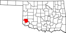 | |
| Towns | ||
| Unincorporated community | ||
| Ghost town | ||