Grandview, Oklahoma
| Grandview, Oklahoma | |
|---|---|
| Census-designated place | |
 Grandview | |
| Coordinates: 35°57′6″N 94°59′37″W / 35.95167°N 94.99361°WCoordinates: 35°57′6″N 94°59′37″W / 35.95167°N 94.99361°W | |
| Country | United States |
| State | Oklahoma |
| County | Cherokee |
| Area | |
| • Total | 3.4 sq mi (8.8 km2) |
| • Land | 3.4 sq mi (8.8 km2) |
| • Water | 0.0 sq mi (0.0 km2) |
| Elevation | 987 ft (301 m) |
| Population (2010) | |
| • Total | 394 |
| • Density | 115/sq mi (44.5/km2) |
| Time zone | UTC-6 (Central (CST)) |
| • Summer (DST) | UTC-5 (CST) |
| FIPS code | 40-30915 |
| GNIS feature ID | 2631111 |
Grandview is an unincorporated area and census-designated place (CDP) in Cherokee County, Oklahoma, United States. The population was 394 at the 2010 census.[1]
Geography
Grandview is located near the center of Cherokee County, on the northwest border of Tahlequah, the Cherokee County seat. Oklahoma State Highway 51 Spur, a western bypass of Tahlequah, runs just southeast of the border of Grandview.
According to the United States Census Bureau, the Grandview CDP has a total area of 3.4 square miles (8.8 km2), all land.[1]
References
- 1 2 "Geographic Identifiers: 2010 Demographic Profile Data (G001): Grandview CDP, Oklahoma". U.S. Census Bureau, American Factfinder. Retrieved February 18, 2015.
Municipalities and communities of Cherokee County, Oklahoma, United States | ||
|---|---|---|
| City | 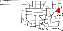 | |
| Towns | ||
| CDPs | ||
| Other unincorporated communities | ||
| Footnotes | ‡This populated place also has portions in an adjacent county or counties | |
This article is issued from
Wikipedia.
The text is licensed under Creative Commons - Attribution - Sharealike.
Additional terms may apply for the media files.