Grande Fache
| Grande Fache | |
|---|---|
| Gran Facha | |
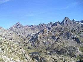 The cirque of Piedrafita - Grande Fache is the high peak to the left. | |
| Highest point | |
| Elevation | 3,005 m (9,859 ft) |
| Prominence | 283 metres (928 ft) |
| Listing | List of Pyrenean three-thousanders |
| Coordinates | 42°48′31″N 0°14′16″E / 42.80861°N 0.23778°ECoordinates: 42°48′31″N 0°14′16″E / 42.80861°N 0.23778°E |
| Geography | |
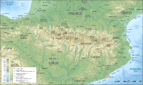 Grande Fache Location in the Pyrenees | |
| Location | France — Spain |
| Région Communauté |
Midi-Pyrénées Aragon |
| Département Province |
Hautes-Pyrénées Huesca |
| Parent range | Pyrenees |
| Climbing | |
| First ascent | 1874 by Henry Russell and Cauterets Latour |
La Grande Fache, Gran Facha or Cuspide de Bachimaña is a summit in the Pyrenees, culminating at 3,005 m, situated on the French-Spanish border and on the pyrenean watershed.
Topography
It rises at the centre of the cirques of Marcadau, Piedrafita and Bachimaña, and is surrounded by many lakes or Ibóns.
Given its high altitude and pyramidal form, it is a well climbed summit.
History
The first ascent was carried out by Henry Russell and guide Cauterets Latour in the summer of 1874.[1]
Access
From France, a path starts from the Wallon valley and another from the zone de Respomuso (cirque de Piedrafita).
From Spain, the path starts at la Sarra marsh (Sallent de Gállego), goes past the Respumuso dam, the ibón de Campoplano, the Ibóns de la Fache, the port de la Fache and ends by steep slopes up to the summit.
References
| Wikimedia Commons has media related to Grande Fache. |
- ↑ Henri Russell, Souvenirs d'un montagnard.