Grammatiko
| Grammatiko Γραμματικό | |
|---|---|
 Grammatiko Location within the regional unit 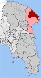 | |
| Coordinates: 38°12′N 23°58′E / 38.200°N 23.967°ECoordinates: 38°12′N 23°58′E / 38.200°N 23.967°E | |
| Country | Greece |
| Administrative region | Attica |
| Regional unit | East Attica |
| Municipality | Marathon |
| • Municipal unit | 51.674 km2 (19.951 sq mi) |
| Elevation | 211 m (692 ft) |
| Population (2011)[1] | |
| • Municipal unit | 1,823 |
| • Municipal unit density | 35/km2 (91/sq mi) |
| Time zone | UTC+2 (EET) |
| • Summer (DST) | UTC+3 (EEST) |
| Postal code | 190 07 |
| Area code(s) | 22940 |
| Vehicle registration | Z |
Grammatiko (Greek: Γραμματικό) is a village in East Attica, Greece. Since the 2011 local government reform it is part of the municipality Marathon, of which it is a municipal unit.[2]
Geography
Grammatiko is situated in the hills of the northeastern part of the Attica peninsula, 6 km from the South Euboean Gulf coast, at about 210 m elevation. It is 4 km southeast of Varnavas, 5 km north of Marathon and 32 km northeast of Athens city centre. The municipal unit Grammatiko consists of the villages Grammatiko, Agia Marina and Sesi. It has an area of 51.674 km2.[3]
Helios Airways Flight 522 crashed in the hills near Grammatiko on 14 of August 2005 after a lack of cabin pressure incapacitated the aircraft's crew members.
Historical population
| Year | Village population | Community population |
|---|---|---|
| 1981 | - | 1,236 |
| 1991 | 1,177 | 1,498 |
| 2001 | 1,284 | 1,443 |
| 2011 | 1,432 | 1,823 |
References
- ↑ "Απογραφή Πληθυσμού - Κατοικιών 2011. ΜΟΝΙΜΟΣ Πληθυσμός" (in Greek). Hellenic Statistical Authority.
- ↑ Kallikratis law Greece Ministry of Interior (in Greek)
- ↑ "Population & housing census 2001 (incl. area and average elevation)" (PDF) (in Greek). National Statistical Service of Greece. Archived from the original (PDF) on 2015-09-21.
Places adjacent to Grammatiko | |
|---|---|
This article is issued from
Wikipedia.
The text is licensed under Creative Commons - Attribution - Sharealike.
Additional terms may apply for the media files.