Grade I listed buildings in Medway
There are over 9,000 Grade I listed buildings in England. This page is a list of these buildings in the district of Medway in Kent.
Medway
| Name | Location | Type | Completed [note 1] | Date designated | Grid ref.[note 2] Geo-coordinates |
Entry number [note 3] | Image |
|---|---|---|---|---|---|---|---|
| Church of All Saints | Allhallows, Medway | Parish Church | 12th century | 21 November 1966 | TQ8359777547 51°28′02″N 0°38′31″E / 51.467105°N 0.641842°E |
1085758 | 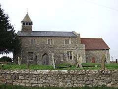 |
| Church of St Helen | Cliffe and Cliffe Woods, Medway | Collegiate Church | c. 1200 | 21 November 1966 | TQ7359476626 51°27′43″N 0°29′51″E / 51.461986°N 0.497529°E |
1204042 | 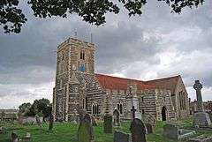 |
| Church of St James | Cooling, Medway | Parish Church | C13-C15 | 21 November 1966 | TQ7562475949 51°27′19″N 0°31′35″E / 51.455279°N 0.526385°E |
1204117 |  |
| Cooling Castle Gatehouse | Cooling, Medway | Castle | 1381-85 | 21 November 1966 | TQ7538775892 51°27′17″N 0°31′23″E / 51.45484°N 0.522949°E |
1085770 |  |
| Inner Ward to Cooling Castle | Cooling, Medway | Castle | seat after 1214 | 21 November 1966 | TQ7536875942 51°27′19″N 0°31′22″E / 51.455295°N 0.522701°E |
1085771 |  |
| Church of St Michael | Cuxton, Medway | Parish Church | 12th century | 21 November 1966 | TQ7095966451 51°22′17″N 0°27′17″E / 51.371382°N 0.454733°E |
1085774 | 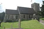 |
| Barn 30 Yards South West of the Manor House | Frindsbury Extra, Medway | Aisled Barn | c. 1300 | 27 August 1952 | TQ7469470041 51°24′09″N 0°30′36″E / 51.402495°N 0.510102°E |
1204320 | |
| The Barracks | Upnor, Frindsbury Extra, Medway | Barracks | 1717-18 | 14 November 1986 | TQ7581070502 51°24′23″N 0°31′35″E / 51.406292°N 0.526358°E |
1085742 | |
| Upnor Castle | Upper Upnor, Frindsbury Extra, Medway | Moat | 1599-1601 | 14 November 1986 | TQ7585670574 51°24′25″N 0°31′37″E / 51.406924°N 0.527055°E |
1204365 | 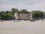 |
| Church of St John the Baptist | Halling, Medway | Parish Church | 12th century | 21 November 1966 | TQ7052163886 51°20′54″N 0°26′50″E / 51.348471°N 0.447217°E |
1085746 | 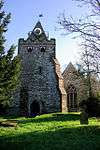 |
| Church of St Margaret | High Halstow, Medway | Parish Church | 13th century | 21 January 1966 | TQ7797675278 51°26′55″N 0°33′36″E / 51.448518°N 0.559864°E |
1204435 | 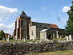 |
| Church of St Werburgh | Hoo St. Werburgh, Medway | Parish Church | C12-C15 | 21 November 1966 | TQ7834671856 51°25′04″N 0°33′48″E / 51.417663°N 0.563462°E |
1204440 | 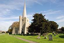 |
| Church of St James | Isle of Grain, Medway | Parish Church | 12th century | 21 November 1966 | TQ8887476789 51°27′31″N 0°43′02″E / 51.458562°N 0.71732°E |
1085755 | 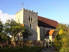 |
| Church of St Peter and St Paul | Stoke, Medway | Parish Church | 12th century | 21 November 1966 | TQ8234275073 51°26′43″N 0°37′21″E / 51.445288°N 0.62252°E |
1204545 |  |
| Cathedral Church of Christ and the Blessed Virgin Mary of Rochester | Rochester, Medway | Cathedral | C7 | 24 October 1950 | TQ7427368521 51°23′20″N 0°30′12″E / 51.38897°N 0.50331°E |
1086423 | 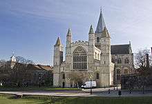 |
| Cathedral Cloister Buildings | Rochester, Medway | Wall | Roman | 24 October 1950 | TQ7425768489 51°23′19″N 0°30′11″E / 51.388688°N 0.503065°E |
1086461 | 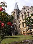 |
| Chertsey's Gate | Rochester, Medway | Gate | Probably mid 14th century | 24 October 1950 | TQ7429368603 51°23′23″N 0°30′13″E / 51.389701°N 0.503638°E |
1086494 |  |
| Church of St Margaret | Rainham, Medway | Church | c. 1066 | 24 February 1950 | TQ8173665881 51°21′47″N 0°36′33″E / 51.362918°N 0.609104°E |
1267793 | 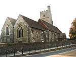 |
| Cloister Gate | Rochester, Medway | Gate | 12th century | 2 December 1991 | TQ7423968480 51°23′19″N 0°30′10″E / 51.388612°N 0.502802°E |
1320354 |  |
| Deanery Gate and Gatehouse | Rochester, Medway | House | Mid-late 18th century | 24 October 1950 | TQ7429268544 51°23′21″N 0°30′13″E / 51.389171°N 0.503594°E |
1115637 | 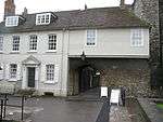 |
| Dickens Chalet to Rear of Eastgate House | Eastgate, Rochester, Medway | Chalet | 19th century | 24 October 1950 | TQ7448068345 51°23′14″N 0°30′22″E / 51.387326°N 0.506196°E |
1116244 | 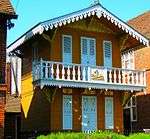 |
| Eastgate House | Eastgate, Rochester, Medway | Jettied House | 1590-1 | 24 October 1950 | TQ7447368342 51°23′14″N 0°30′22″E / 51.387301°N 0.506094°E |
1086482 | 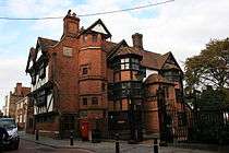 |
| Former Commissioners House and attached Staff Accommodation | Chatham Dockyard, Medway | Naval Officers House | 1703 | 24 May 1971 | TQ7587669080 51°23′37″N 0°31′36″E / 51.393498°N 0.526602°E |
1268201 |  |
| Former Lead and Paint Mill | Chatham Dockyard, Medway | Paint Factory | 1817-1819 | 13 August 1999 | TQ7582368757 51°23′26″N 0°31′32″E / 51.390613°N 0.525681°E |
1378588 | |
| Former Mast House and Mould Loft | Chatham Dockyard, Medway | Mast House | 1753-1755 | 13 August 1999 | TQ7602569434 51°23′48″N 0°31′44″E / 51.396631°N 0.528917°E |
1378590 | 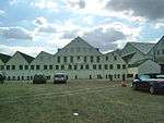 |
| Former Officers Terrace and Attached Front Area Walls and Overthrows | Chatham Dockyard, Medway | Naval Officers House | 1722-1731 | 24 May 1971 | TQ7598269154 51°23′39″N 0°31′41″E / 51.39413°N 0.528161°E |
1268220 | 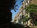 |
| Former Storehouse Number 2 and Former Rigging Store | Chatham Dockyard, Medway | Rigging House | 1793-1796 | 13 August 1999 | TQ7578368951 51°23′33″N 0°31′31″E / 51.392368°N 0.525203°E |
1378585 | |
| Former Storehouse Number 3 and Former Chain Cable Store | Chatham Dockyard, Medway | Warehouse | 1773-1783 | 13 August 1999 | TQ7574268765 51°23′27″N 0°31′28″E / 51.39071°N 0.524522°E |
1378584 | |
| Kings School and Cathedral Visitors Centre | Medway | Deanery | Late Medieval | 24 October 1950 | TQ7431168461 51°23′18″N 0°30′14″E / 51.38842°N 0.503827°E |
1086421 | |
| Main Gate and attached Dockyard Perimeter Wall to South West | Chatham Dockyard, Medway | Boundary Wall | 1718 | 24 May 1971 | TQ7588168888 51°23′30″N 0°31′36″E / 51.391771°N 0.526579°E |
1268202 |  |
| Minor Canons' Row | Medway | Clergy House | 1736 | 24 October 1950 | TQ7423568444 51°23′18″N 0°30′10″E / 51.38829°N 0.502727°E |
1139023 | 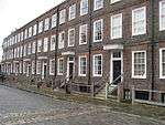 |
| Number 3 Slip Cover | Chatham Dockyard, Medway | Slip Shed | 1838 | 13 August 1999 | TQ7590369410 51°23′47″N 0°31′38″E / 51.396454°N 0.527153°E |
1378591 | 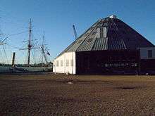 |
| Number 7 Slip Cover and Machine Shop Number 3 | Chatham Dockyard, Medway | Slip Shed | 1852-1855 | 13 August 1999 | TQ7599369576 51°23′53″N 0°31′43″E / 51.397917°N 0.528528°E |
1378595 | 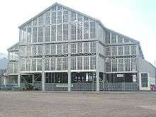 |
| Numbers 4 5 and 6 Slip Covers and Machine Shop Number 6 | Chatham Dockyard, Medway | Slip Shed | 1845-1847 | 13 August 1999 | TQ7595169499 51°23′50″N 0°31′40″E / 51.397238°N 0.527886°E |
1378594 | 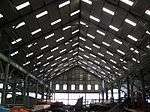 |
| Parish Church of St Nicholas | Rochester, Medway | Parish Church | 1421-23 | 24 October 1950 | TQ7428268570 51°23′22″N 0°30′12″E / 51.389408°N 0.503464°E |
1299749 | 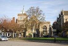 |
| Poor Travellers House / Richard Watts Charity | Medway | House | 1950 | 24 October 1950 | TQ7437668495 51°23′19″N 0°30′17″E / 51.388705°N 0.504776°E |
1086479 | 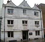 |
| Priors Gate | Rochester, Medway | Gate | 1344 | 24 October 1950 | TQ7420468450 51°23′18″N 0°30′08″E / 51.388354°N 0.502285°E |
1086428 | 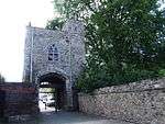 |
| Public Library (former Corn Exchange) to Rear of High Street, the Corn Exchange the Corn Exchange | Rochester, Medway | Corn Exchange | 1706 | 23 August 1974 | TQ7432168655 51°23′25″N 0°30′15″E / 51.390159°N 0.504065°E |
1086474 | 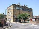 |
| Restoration House including Wall and Gatepiers attached to Front | Medway | Cross Passage House | Late Medieval | 24 October 1950 | TQ7436368213 51°23′10″N 0°30′16″E / 51.386176°N 0.504451°E |
1185341 | 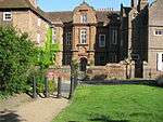 |
| Rochester Castle | Rochester, Medway | Castle | 1087-89 | 24 October 1950 | TQ7413768560 51°23′22″N 0°30′05″E / 51.389362°N 0.501377°E |
1336100 | 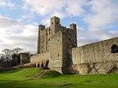 |
| Rochester City Walls | Rochester, Medway | Bastion | Mid 14th century | 24 October 1950 | TQ7437268345 51°23′14″N 0°30′17″E / 51.387359°N 0.504645°E |
1086506 |  |
| Sail Loft | Chatham Dockyard, Medway | Sail Loft | c. 1723 | 13 August 1999 | TQ7595169034 51°23′35″N 0°31′40″E / 51.393061°N 0.527656°E |
1378586 |  |
| Section of Roman Wall 20 Metres South of Former Deanery Section of Roman Wall 20 Metres South of Kings School Sixth Form Centre | Medway | Wall | Roman | 19 February 1970 | TQ7430468430 51°23′17″N 0°30′13″E / 51.388143°N 0.503711°E |
1336174 | |
| Temple Manor | Strood, Medway | Farmhouse | second and third quarter 17th century | 24 October 1950 | TQ7331368535 51°23′22″N 0°29′22″E / 51.38939°N 0.489534°E |
1120910 | 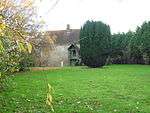 |
| The Brunel Saw Mill | Chatham Dockyard, Medway | Fireproof Building | 1810-1814 | 24 May 1971 | TQ7617269302 51°23′43″N 0°31′51″E / 51.3954°N 0.530962°E |
1268231 | 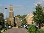 |
| The Guildhall including Ranges Running Parallel to Bull Lane | Rochester, Medway | Local Government Office | 1864-66 | 24 October 1950 | TQ7424068741 51°23′27″N 0°30′11″E / 51.390957°N 0.502944°E |
1186145 | 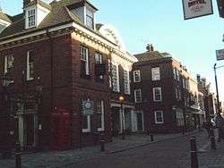 |
| The Ropery and Spinning Room | Chatham Dockyard, Medway | Ropery | 1785-1791 | 24 May 1971 | TQ7578768842 51°23′29″N 0°31′31″E / 51.391387°N 0.525206°E |
1268250 | 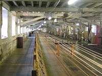 |
| 150, 152 and 154 High Street | Eastgate, Rochester, Medway | Apartment | 1950 | 24 October 1950 | TQ7447968299 51°23′13″N 0°30′22″E / 51.386913°N 0.506159°E |
1086499 | 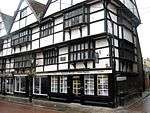 |
Notes
- ↑ The date given is the date used by Historic England as significant for the initial building or that of an important part in the structure's description.
- ↑ Sometimes known as OSGB36, the grid reference is based on the British national grid reference system used by the Ordnance Survey.
- ↑ The "List Entry Number" is a unique number assigned to each listed building and scheduled monument by Historic England.
External links
![]()
This article is issued from
Wikipedia.
The text is licensed under Creative Commons - Attribution - Sharealike.
Additional terms may apply for the media files.