Graboszyce
| Graboszyce | |
|---|---|
| Village | |
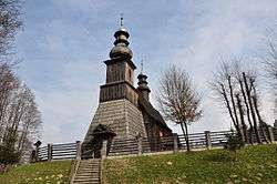 Saint Andrew church | |
 Graboszyce | |
| Coordinates: 49°57′N 19°27′E / 49.950°N 19.450°E | |
| Country |
|
| Voivodeship | Lesser Poland |
| County | Oświęcim |
| Gmina | Zator |
| Highest elevation | 280 m (920 ft) |
| Lowest elevation | 235 m (771 ft) |
| Population (approx.) | 750 |
Graboszyce [ɡrabɔˈʂɨt͡sɛ] is a village in the administrative district of Gmina Zator, within Oświęcim County, Lesser Poland Voivodeship, in southern Poland.[1] It lies approximately 6 kilometres (4 mi) south of Zator, 20 km (12 mi) south-east of Oświęcim, and 38 km (24 mi) west of the regional capital Kraków.
The village has an approximate population of 750.
References
| Wikimedia Commons has media related to Graboszyce. |
| Town and seat |  | |
|---|---|---|
| Villages | ||
This article is issued from
Wikipedia.
The text is licensed under Creative Commons - Attribution - Sharealike.
Additional terms may apply for the media files.