Delligsen
| Delligsen | ||
|---|---|---|
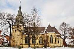 Church in Delligsen | ||
| ||
 Delligsen Location of Delligsen within Holzminden district 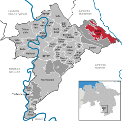  | ||
| Coordinates: 51°57′N 9°48′E / 51.950°N 9.800°ECoordinates: 51°57′N 9°48′E / 51.950°N 9.800°E | ||
| Country | Germany | |
| State | Lower Saxony | |
| District | Holzminden | |
| Government | ||
| • Mayor | Hans-Dieter Krösche | |
| Area | ||
| • Total | 36.01 km2 (13.90 sq mi) | |
| Elevation | 191 m (627 ft) | |
| Population (2017-12-31)[1] | ||
| • Total | 7,844 | |
| • Density | 220/km2 (560/sq mi) | |
| Time zone | CET/CEST (UTC+1/+2) | |
| Postal codes | 31073 | |
| Dialling codes | 05187 | |
| Vehicle registration | HOL | |
| Website | www.delligsen.de | |

Delligsen is a municipality in Holzminden district, in Lower Saxony, Germany. It consists of six localities which were independent until 1974: Delligsen itself, Grünenplan, Ammensen, Hohenbüchen, Kaierde and Varrigsen. The area is dominated by the massif of the Hils hills
Delligsen itself has been an industrial settlement dominated by the Friedrich-Carls-Hütte ironworks which closed down in 1984.
Grünenplan further up in the Hils is an officially designated climate health resort. It has three centuries of history in glass manufacturing and still has a Schott AG glass factory. The factory was founded in 1744 by the prince of Brunswick's government in order to produce large mirrors.
Towns and municipalities in Holzminden (district) | ||
|---|---|---|
References
This article is issued from
Wikipedia.
The text is licensed under Creative Commons - Attribution - Sharealike.
Additional terms may apply for the media files.