Gréville-Hague
| Gréville-Hague | |
|---|---|
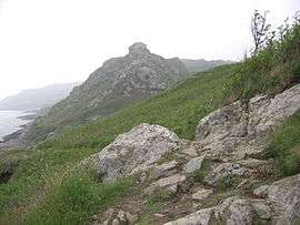 The rock of Castel Vendon | |
 Gréville-Hague Location within Normandy region  Gréville-Hague | |
| Coordinates: 49°40′30″N 1°48′00″W / 49.675°N 1.800°WCoordinates: 49°40′30″N 1°48′00″W / 49.675°N 1.800°W | |
| Country | France |
| Region | Normandy |
| Department | Manche |
| Arrondissement | Cherbourg |
| Canton | La Hague |
| Area1 | 10.03 km2 (3.87 sq mi) |
| Population (2006)2 | 783 |
| • Density | 78/km2 (200/sq mi) |
| Demonym(s) | Grévillais |
| Time zone | UTC+1 (CET) |
| • Summer (DST) | UTC+2 (CEST) |
| INSEE/Postal code | 50220 /50440 |
| Elevation | 0–167 m (0–548 ft) |
| Website | www.greville-hague.fr |
|
1 French Land Register data, which excludes lakes, ponds, glaciers > 1 km2 (0.386 sq mi or 247 acres) and river estuaries. 2 Population without double counting: residents of multiple communes (e.g., students and military personnel) only counted once. | |
Gréville-Hague is a former commune in the Manche department in Normandy in north-western France. On 1 January 2017, it was merged into the new commune La Hague.[1] A hamlet (Gruchy) of the village is the birthplace of Jean-François Millet, a notable impressionist painter. Several of his most important paintings depict local landscapes or rural labour.
Location of a major World War II battery, as well as massive French fortifications (never completed) to protect the deep-water port of Cherbourg.
See also
References
- ↑ Arrêté préfectoral 27 September 2016 (in French)
| Wikimedia Commons has media related to Gréville-Hague. |
This article is issued from
Wikipedia.
The text is licensed under Creative Commons - Attribution - Sharealike.
Additional terms may apply for the media files.