Gråkallen
| Gråkallen | |
|---|---|
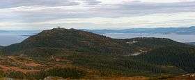 Gråkallen seen from Storheia | |
| Highest point | |
| Elevation | 552 m (1,811 ft) |
| Prominence | 160 m (520 ft) |
| Parent peak | Storheia |
| Coordinates | 63°25′14″N 10°15′05″E / 63.42056°N 10.25139°ECoordinates: 63°25′14″N 10°15′05″E / 63.42056°N 10.25139°E [1] |
| Geography | |
 Gråkallen Location of the mountain  Gråkallen Gråkallen (Norway) | |
| Location | Trøndelag, Norway |
| Topo map | 1621 IV Trondheim |
| Climbing | |
| Easiest route | Road |
Gråkallen is a mountain in the Bymarka area in the municipality of Trondheim in Trøndelag county, Norway. The 552-metre (1,811 ft) tall mountain is located in the Byåsen part of the city of Trondheim.
The summit is covered by an abandoned fenced military installation. Below the summit (on the col to the right of the summit above the lake) there is a ski station accessible by bus from Trondheim. In the summer, the ski runs through the pine forests allow hiking and mountain biking back to the city below.
Name
The first element is grå which means "grey" and the last element is the finite form of kall which means "old man". (It is common in Norway to compare mountains with old men.)[2]
References
- ↑ "Gråkallen, Trondheim (Trøndelag)" (in Norwegian). yr.no. Retrieved 2018-03-18.
- ↑ Rosvold, Knut A., ed. (2018-02-20). "Gråkallen". Store norske leksikon (in Norwegian). Kunnskapsforlaget. Retrieved 2018-03-18.
This article is issued from
Wikipedia.
The text is licensed under Creative Commons - Attribution - Sharealike.
Additional terms may apply for the media files.