Gowganda
| Gowganda | |
|---|---|
| Dispersed Rural Community | |
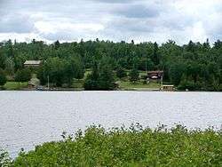 Lookout Point Lodge, seen from Gowganda Lake at Gowganda | |
 Gowganda Location in Ontario | |
| Coordinates: 47°38′57″N 80°46′13″W / 47.64917°N 80.77028°WCoordinates: 47°38′57″N 80°46′13″W / 47.64917°N 80.77028°W[1] | |
| Country | Canada |
| Province | Ontario |
| District | Timiskaming |
| Geographic township | Nicol |
| Elevation[2] | 356 m (1,168 ft) |
| Time zone | UTC-5 (Eastern Time Zone) |
| • Summer (DST) | UTC-4 (Eastern Time Zone) |
| Postal Code | P0J 1J0 |
| Area code(s) | 705, 249 |
Gowganda is a Dispersed Rural Community and unincorporated place in geographic Nicol Township,[3] Timiskaming District, in northeastern Ontario, Canada.[1] It is at the outlet of the Montreal River from Lake Gowganda, and is on Ontario Highway 560.
.jpg)
post office in Gowganda, 1910
References
- 1 2 "Gowganda". Geographical Names Data Base. Natural Resources Canada. Retrieved 2016-12-22.
- ↑ Elevation taken at geographic coordinates from Google Maps. Accessed 2016-12-22.
- ↑ "Nicol" (PDF). Geology Ontario - Historic Claim Maps. Ontario Ministry of Northern Development, Mines and Forestry. Retrieved 2016-12-22.
External links
- Gowganda profile at the James Bay Frontier Travel Association
- North Ontario Fishing Maps Angler's Atlas map download
This article is issued from
Wikipedia.
The text is licensed under Creative Commons - Attribution - Sharealike.
Additional terms may apply for the media files.