Gornji Ajdovec
| Gornji Ajdovec | |
|---|---|
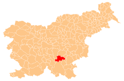
 Gornji Ajdovec Location in Slovenia | |
| Coordinates: 45°49′34.49″N 15°0′50.93″E / 45.8262472°N 15.0141472°ECoordinates: 45°49′34.49″N 15°0′50.93″E / 45.8262472°N 15.0141472°E | |
| Country |
|
| Traditional region | Lower Carniola |
| Statistical region | Southeast Slovenia |
| Municipality | Žužemberk |
| Area | |
| • Total | 1.08 km2 (0.42 sq mi) |
| Elevation | 454.9 m (1,492.5 ft) |
| Population (2002) | |
| • Total | 47 |
| [1] | |
Gornji Ajdovec (pronounced [ˈɡoːɾnji ˈaːi̯dɔʋəts], in older sources Gorenja Ajdovica,[2] German: Oberhaidowitz[2]) is a settlement in the Municipality of Žužemberk in southeastern Slovenia. It lies in the hills to the east of Dvor in the historical region of Lower Carniola. The municipality is now included in the Southeast Slovenia Statistical Region.[3]
References
- ↑ Statistical Office of the Republic of Slovenia
- 1 2 Leksikon občin kraljestev in dežel zastopanih v državnem zboru, vol. 6: Kranjsko. Vienna: C. Kr. Dvorna in Državna Tiskarna. 1906. p. 170.
- ↑ Žužemberk municipal site
External links
This article is issued from
Wikipedia.
The text is licensed under Creative Commons - Attribution - Sharealike.
Additional terms may apply for the media files.