Gornergrat Railway
| Gornergrat Railway | |||||||||||||||||||||||||||||||||||||||||||||||||||||||||||||||||||||||||||||||||||||||||||||||||||||||||||||||||||||||||||||||||||||||||||||||||||||||||||||||||||||||||||||||||||||||||||||||||||||||||||||||||||||||||||||||||||||||||||||||||||||||||||||||||||||
|---|---|---|---|---|---|---|---|---|---|---|---|---|---|---|---|---|---|---|---|---|---|---|---|---|---|---|---|---|---|---|---|---|---|---|---|---|---|---|---|---|---|---|---|---|---|---|---|---|---|---|---|---|---|---|---|---|---|---|---|---|---|---|---|---|---|---|---|---|---|---|---|---|---|---|---|---|---|---|---|---|---|---|---|---|---|---|---|---|---|---|---|---|---|---|---|---|---|---|---|---|---|---|---|---|---|---|---|---|---|---|---|---|---|---|---|---|---|---|---|---|---|---|---|---|---|---|---|---|---|---|---|---|---|---|---|---|---|---|---|---|---|---|---|---|---|---|---|---|---|---|---|---|---|---|---|---|---|---|---|---|---|---|---|---|---|---|---|---|---|---|---|---|---|---|---|---|---|---|---|---|---|---|---|---|---|---|---|---|---|---|---|---|---|---|---|---|---|---|---|---|---|---|---|---|---|---|---|---|---|---|---|---|---|---|---|---|---|---|---|---|---|---|---|---|---|---|---|---|---|---|---|---|---|---|---|---|---|---|---|---|---|---|---|---|---|---|---|---|---|---|---|---|---|---|---|---|---|---|---|---|---|
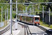
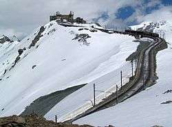 A train approaching the summit station | |||||||||||||||||||||||||||||||||||||||||||||||||||||||||||||||||||||||||||||||||||||||||||||||||||||||||||||||||||||||||||||||||||||||||||||||||||||||||||||||||||||||||||||||||||||||||||||||||||||||||||||||||||||||||||||||||||||||||||||||||||||||||||||||||||||
| Overview | |||||||||||||||||||||||||||||||||||||||||||||||||||||||||||||||||||||||||||||||||||||||||||||||||||||||||||||||||||||||||||||||||||||||||||||||||||||||||||||||||||||||||||||||||||||||||||||||||||||||||||||||||||||||||||||||||||||||||||||||||||||||||||||||||||||
| Native name | Gornergrat Bahn (GGB) | ||||||||||||||||||||||||||||||||||||||||||||||||||||||||||||||||||||||||||||||||||||||||||||||||||||||||||||||||||||||||||||||||||||||||||||||||||||||||||||||||||||||||||||||||||||||||||||||||||||||||||||||||||||||||||||||||||||||||||||||||||||||||||||||||||||
| Operation | |||||||||||||||||||||||||||||||||||||||||||||||||||||||||||||||||||||||||||||||||||||||||||||||||||||||||||||||||||||||||||||||||||||||||||||||||||||||||||||||||||||||||||||||||||||||||||||||||||||||||||||||||||||||||||||||||||||||||||||||||||||||||||||||||||||
| Owner | BVZ Holding | ||||||||||||||||||||||||||||||||||||||||||||||||||||||||||||||||||||||||||||||||||||||||||||||||||||||||||||||||||||||||||||||||||||||||||||||||||||||||||||||||||||||||||||||||||||||||||||||||||||||||||||||||||||||||||||||||||||||||||||||||||||||||||||||||||||
| Technical | |||||||||||||||||||||||||||||||||||||||||||||||||||||||||||||||||||||||||||||||||||||||||||||||||||||||||||||||||||||||||||||||||||||||||||||||||||||||||||||||||||||||||||||||||||||||||||||||||||||||||||||||||||||||||||||||||||||||||||||||||||||||||||||||||||||
| Line length | 9.339 km (5.803 mi) | ||||||||||||||||||||||||||||||||||||||||||||||||||||||||||||||||||||||||||||||||||||||||||||||||||||||||||||||||||||||||||||||||||||||||||||||||||||||||||||||||||||||||||||||||||||||||||||||||||||||||||||||||||||||||||||||||||||||||||||||||||||||||||||||||||||
| Number of tracks |
Single track | ||||||||||||||||||||||||||||||||||||||||||||||||||||||||||||||||||||||||||||||||||||||||||||||||||||||||||||||||||||||||||||||||||||||||||||||||||||||||||||||||||||||||||||||||||||||||||||||||||||||||||||||||||||||||||||||||||||||||||||||||||||||||||||||||||||
| Track gauge | 1,000 mm (3 ft 3 3⁄8 in) metre gauge[1][2] | ||||||||||||||||||||||||||||||||||||||||||||||||||||||||||||||||||||||||||||||||||||||||||||||||||||||||||||||||||||||||||||||||||||||||||||||||||||||||||||||||||||||||||||||||||||||||||||||||||||||||||||||||||||||||||||||||||||||||||||||||||||||||||||||||||||
| Electrification |
725 V, 50 Hz, 3-phase,[1][2] 2 Overhead lines[1] | ||||||||||||||||||||||||||||||||||||||||||||||||||||||||||||||||||||||||||||||||||||||||||||||||||||||||||||||||||||||||||||||||||||||||||||||||||||||||||||||||||||||||||||||||||||||||||||||||||||||||||||||||||||||||||||||||||||||||||||||||||||||||||||||||||||
| Highest elevation | 3,089 m (10,135 ft) | ||||||||||||||||||||||||||||||||||||||||||||||||||||||||||||||||||||||||||||||||||||||||||||||||||||||||||||||||||||||||||||||||||||||||||||||||||||||||||||||||||||||||||||||||||||||||||||||||||||||||||||||||||||||||||||||||||||||||||||||||||||||||||||||||||||
| Rack system | Abt[1][2] | ||||||||||||||||||||||||||||||||||||||||||||||||||||||||||||||||||||||||||||||||||||||||||||||||||||||||||||||||||||||||||||||||||||||||||||||||||||||||||||||||||||||||||||||||||||||||||||||||||||||||||||||||||||||||||||||||||||||||||||||||||||||||||||||||||||
| |||||||||||||||||||||||||||||||||||||||||||||||||||||||||||||||||||||||||||||||||||||||||||||||||||||||||||||||||||||||||||||||||||||||||||||||||||||||||||||||||||||||||||||||||||||||||||||||||||||||||||||||||||||||||||||||||||||||||||||||||||||||||||||||||||||
The Gornergrat Railway (German: Gornergrat Bahn; GGB) is a mountain rack railway, located in the Swiss canton of Valais. It links the resort village of Zermatt, situated at 1,604 m (5,262 ft) above mean sea level, to the summit of the Gornergrat. The Gornergrat railway station is situated at an altitude of 3,089 m (10,135 ft), which makes the Gornergrat Railway the second highest railway in Europe after the Jungfrau, and the highest open-air railway of the continent. The line opened in 1898, and was the first electric rack railway to be built in Switzerland.[1][2][3]
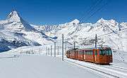
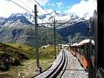
The Gornergrat is a starting point for many hikes, as it lies surrounded by 29 peaks rising above 4,000 m (13,123 ft) in the Alps and several glaciers, including the Gorner Glacier (which is billed as the second longest glacier in the Alps). At the end of the line on Gornergrat, the Matterhorn is visible on a clear day. It is also a popular skiing area.[3]
The Gornergrat Railway Ltd (Gornergrat Bahn AG) is a wholly owned subsidiary of BVZ Holdings AG, who are also the majority owners of the Matterhorn Gotthard Verkehrs AG, the company that operates the Matterhorn Gotthard Bahn (MGB), with which the GGB connects in Zermatt.[3][4]
History
Work on the railway started in 1896, five years after the Visp-Zermatt-Bahn had linked Zermatt to Visp and the Rhone Valley. The line opened on August 20, 1898, and was electrified from the start. Initially it only operated in summer, but year-round operation was extended to the lower section of the line in 1929, and to the summit in 1941.[3][5]
The upper terminal was remodelled in 2004.
Operation
Route
There are several passenger stops on the line:[6][7]
| Station | Distance | Height (AMSL) | Notes |
|---|---|---|---|
| Zermatt | 0.00 |
1,605 m (5,266 ft) |
Link to Matterhorn Gotthard Bahn and the Zermatt–Sunnegga funicular |
| Findelbach | 1.75 km (1.09 mi) |
1,770 m (5,810 ft) |
|
| Riffelalp | 4.03 km (2.50 mi) |
2,211 m (7,254 ft) |
Link to the Riffelalp tram, providing connection to Riffelalp Resort |
| Riffelberg | 6.47 km (4.02 mi) |
2,582 m (8,471 ft) |
With a three-star hotel |
| Rotenboden | 7.91 km (4.92 mi) |
2,815 m (9,236 ft) |
|
| Gornergrat | 9.34 km (5.80 mi) |
3,089 m (10,135 ft) |
With a three-star hotel and observatory |
The are also freight only stations at Ladegleis Findelbach, which is on a short branch from the passenger station at Findelbach, and at Riffelboden, which is situated between Riffelalp and Riffelberg passenger stations.[7]
Infrastructure
The line is 9,339 m (30,640 ft) in length, including 3,790 m (12,434 ft) of double track, and traverses an altitude difference of 1,469 m (4,820 ft). It is built to metre gauge (3 ft 3 3⁄8 in) and uses the Abt rack system throughout. It is one of four lines in the world using three-phase electric power, requiring two overhead conductors, with the track forming the third conductor.[1][2] There is a non-powered connection with the metre gauge Matterhorn Gotthard Bahn at Zermatt to allow transfer of freight and delivery of rolling stock.
Rolling stock
The line uses the following rolling stock:[7]
| Image | Numbers | Notation | Year | Notes |
|---|---|---|---|---|
| 3001/3003 | He 2/2 | 1898 | Locomotives. Unit 3002 survives, and is displayed on a roundabout at Stalden. | |
| 3015 | Dhe 2/4 | Baggage car, rebuilt from sister car to 3019-3022 | ||
 |
3017 | Xhe 2/4 | Works car, rebuilt from sister car to 3019-3022. Carries re-railing equipment and equipment to apply anti-freeze to the overhead wires. | |
 |
3019-3022 | Bhe 2/4 | 1947-61 | Single unit railcars, remaining four cars of a once much larger class (3011-3022). Two other members of this class have been rebuilt (3015/3017), the remainder have been scrapped. |
 |
3041-3044 | Bhe 4/8 | 1965-75 | Twin unit railcars |
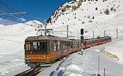 |
3051-3054 | Bhe 4/8 | 1993 | Twin unit railcars |
 |
3061-3062 | Bhe 4/4 | 1981 | Multi-purpose railcars, which can operate in passenger service with matching driving trailers Bt 3071-3072, or in freight/works service. |
 |
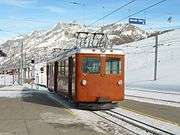
3081-3084 | Bhe 4/6 | 2006 | Low floor two-section articulated railcars, built by Stadler Rail.[8] |
The railway typically operates two-railcar trains, and can carry approximately 2,500 people per hour from Zermatt to the mountain summit.[7]
Gallery
 Above Riffelberg
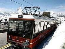 Summit station; the train has two pantographs for the three-phase power-supply
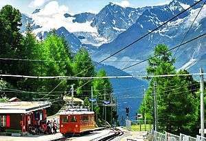 Riffelalp intermediate station. In the left, beside station building, the track of the Riffelalptram
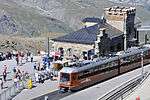 Gornergrat station building
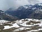 Above Rotenboden
 Switch point
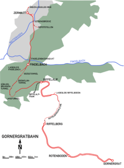 Map of the railway
See also
References
- 1 2 3 4 5 6 Buckley, Richard (2000). Tramways and Light Railways of Switzerland and Austria (2nd edition), p. 86. Gloucester, UK: Light Rail Transit Association. ISBN 0-948106-27-1.
- 1 2 3 4 5 Harris, Ken (Ed.) (2001). Jane's World Railways 2001–2002 (43rd edition), p. 352. Coulsdon, Surrey (UK): Jane's Information Group. ISBN 978-0-7106-2335-5.
- 1 2 3 4 Allen, Cecil J. (1958). Switzerland's Amazing Railways. London: Thomas Nelson and Sons. pp. 130–132.
- ↑ "BVZ Holding AG (BVZN.S)". Reuters. Retrieved 2014-06-12.
- ↑ "Gornergrat Bahn building". www.zermatt.ch. Zermatt Tourism. Retrieved 2014-06-02.
- ↑ "Fahrplan Zermatt - Gornergrat (28.04.2014 - 06.06.2014)" [Timetable Zermatt - Gornergrat (28.04.2014 - 06.06.2014)] (in German). Gornergratbahn. Archived from the original on 2014-06-05. Retrieved 2014-05-30.
- 1 2 3 4 "Betriebsdaten" [Operating data] (in German). Gornergratbahn. Archived from the original on 2014-06-02. Retrieved 2014-05-30.
- ↑ "Zahnrad - Doppeltriebwagen Bhe 4/6 in Niederflurbauweise für die Gornergrat Bahn (GGB)" [Double low floor rack railcar Bhe 4/6 for the Gornergrat Bahn (GGB)] (PDF) (in German). Stadler Rail. Archived from the original (PDF) on 2013-07-31. Retrieved 2014-06-13.
External links
| Wikimedia Commons has media related to Gornergratbahn. |
- Gornergrat Bahn website (English version)