Gorikot Valley
.jpg)
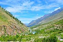
Gorikot is the largest valley in the Astore District of Gilgit-Baltistan, Pakistan, now home to most district government offices; and is the district headquarter. The local name for the town is Gué.
The following are the small villages associated with Gorikot Valley: Gaiynrike, Dingot, Domosur, Kutaan, Shring-Darr, Sargale, Ahmadabad, Hilbeche, Pakoroye, Daryaal, Kinidas, and pirot.
Gorikot lies on the historic junction where roads link Rattu and Tarisheng Base camp-Nanga Perbat, and other axis leads to Gudai – Chilum & Deosai Plains linking Astore to Skardu. The roads are not fully paved but are suitable for local jeeps. The majority of people here are Sunnis. Gorikot is well known for its scenic beauty as lush green plains, lofty mountains and swapping cold winds makes addition to its beauty. In Gorikot, terrace farming is practised in a subsistence scale. Crops like cotton, wheat, peas, and fruits are grown here; apples are a cash crop for landlords and are supplied to places like Islamabad. Fruit drying also occurs.
References
Coordinates: 35°16′49″N 74°51′03″E / 35.28028°N 74.85083°E