Gordonsville, Minnesota
| Gordonsville, Minnesota | |
|---|---|
| Unincorporated community | |
 Gordonsville, Minnesota  Gordonsville, Minnesota | |
| Coordinates: 43°30′46″N 93°15′13″W / 43.51278°N 93.25361°WCoordinates: 43°30′46″N 93°15′13″W / 43.51278°N 93.25361°W | |
| Country | United States |
| State | Minnesota |
| County | Freeborn |
| Elevation | 1,217 ft (371 m) |
| Time zone | UTC-6 (Central (CST)) |
| • Summer (DST) | UTC-5 (CDT) |
| Area code(s) | 507 |
| GNIS feature ID | 644276[1] |
Gordonsville is an unincorporated community in Freeborn County, in the U.S. state of Minnesota.[1]
History
A post office was established at Gordonsville in 1862, and remained in operation until it was discontinued in 1965.[2][3] The community derives its name from T. J. Gordon and W. H. H. Gordon, father and son, who both served as early postmasters.[4] Gordonsville was platted in 1880.[4]
References
- 1 2 U.S. Geological Survey Geographic Names Information System: Gordonsville, Minnesota
- ↑ "Freeborn County". Jim Forte Postal History. Retrieved 4 June 2015.
- ↑ U.S. Geological Survey Geographic Names Information System: Gordonsville Post Office (historical)
- 1 2 Upham, Warren (1920). Minnesota Geographic Names: Their Origin and Historic Significance. Minnesota Historical Society. p. 201.
Municipalities and communities of Freeborn County, Minnesota, United States | ||
|---|---|---|
| Cities | 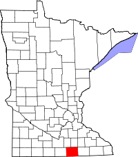 | |
| Townships | ||
| Unincorporated communities | ||
| Footnotes | ‡This populated place also has portions in an adjacent county or counties | |
This article is issued from
Wikipedia.
The text is licensed under Creative Commons - Attribution - Sharealike.
Additional terms may apply for the media files.