Gordonsburg, Tennessee
| Gordonsburg | |
|---|---|
| Unincorporated community | |
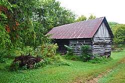 Ambrose Blackburn Farmstead original shed | |
 Gordonsburg Location within the state of Tennessee  Gordonsburg Gordonsburg (the US) | |
| Coordinates: 35°34′11″N 87°25′26″W / 35.56972°N 87.42389°WCoordinates: 35°34′11″N 87°25′26″W / 35.56972°N 87.42389°W | |
| Country | United States |
| State | Tennessee |
| County | Lewis |
| Elevation | 610 ft (190 m) |
| Time zone | UTC-6 (Central (CST)) |
| • Summer (DST) | UTC-5 (CDT) |
| GNIS feature ID | 1315135[1] |
Gordonsburg is an unincorporated community in northeastern Lewis County, Tennessee. It lies at the intersection of U.S. Route 412 with the Natchez Trace Parkway, east of the city of Hohenwald, the county seat of Lewis County.[2] Its elevation is 610 feet (186 m).[1]
References
- 1 2 "Gordonsburg, Tennessee". Geographic Names Information System. United States Geological Survey. Retrieved 2008-05-16.
- ↑ Rand McNally. The Road Atlas '05. Chicago: Rand McNally, 2005, p. 94.
Municipalities and communities of Lewis County, Tennessee, United States | ||
|---|---|---|
| City | ||
| CDP | ||
| Unincorporated communities | ||
| Footnotes | ‡This populated place has portions in an adjacent county or counties | |
This article is issued from
Wikipedia.
The text is licensed under Creative Commons - Attribution - Sharealike.
Additional terms may apply for the media files.