Goose Gap
| Goose Gap | |
|---|---|
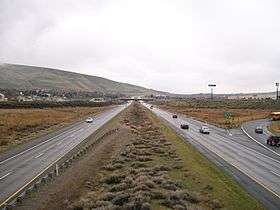 Interstate 182 approaching Goose Gap. | |
| Elevation | 860 ft (262 m)[1] |
| Traversed by |
|
| Location | Benton County, Washington[1] |
| Range | Yakima Fold Belt |
| Coordinates | 46°14′42″N 119°21′26″W / 46.24500°N 119.35722°WCoordinates: 46°14′42″N 119°21′26″W / 46.24500°N 119.35722°W[1] |
Goose Gap is a small pass connecting Badger Mountain to Candy Mountain to the west of Richland, Washington. It lies significantly higher than most of the Tri-Cities and is crossed by Interstate 182 just after its western terminus. An average of 18,000 people cross Goose Gap daily.[3]
There are residential areas on both sides of I-182 to the east of the gap, but to the west is mostly agriculture. The non-profit organization Friends of Badger Mountain is planning a new hiking trail to connect Badger Mountain to Candy Mountain, which will cross Goose Gap in a north-to-south direction, perpendicular to the Interstate.[4]
See also
References
- 1 2 3 "Goose Gap". Geographic Names Information System. United States Geological Survey. Retrieved 2015-08-31.
- ↑ Google Maps Accessed 2015-08-31
- ↑ WSDOT - Annual Traffic Report Accessed 2015-08-31
- ↑ Current Campaign - Friends of Badger Mountain Accessed 2015-08-31.
This article is issued from
Wikipedia.
The text is licensed under Creative Commons - Attribution - Sharealike.
Additional terms may apply for the media files.