Gonsenheim
| Gonsenheim | ||
|---|---|---|
| borough of Mainz | ||
| ||
 Gonsenheim Location of Gonsenheim within Mainz 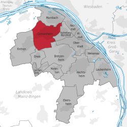 | ||
| Coordinates: 50°0′N 8°12′E / 50.000°N 8.200°ECoordinates: 50°0′N 8°12′E / 50.000°N 8.200°E | ||
| Country | Germany | |
| State | Rhineland-Palatinate | |
| District | Urban districts of Germany | |
| Town | Mainz | |
| Government | ||
| • Mayor | Sabine Flegel (CDU) | |
| Area | ||
| • Total | 9.127 km2 (3.524 sq mi) | |
| Elevation | 115 m (377 ft) | |
| Population (2017-10-31) | ||
| • Total | 25,390 | |
| • Density | 2,800/km2 (7,200/sq mi) | |
| Time zone | CET/CEST (UTC+1/+2) | |
| Postal codes | 55124 + 55122 | |
| Dialling codes | 06131 | |
| Vehicle registration | MZ | |
| Website | Gonsenheim.de | |

Gonsenheim is a borough in the northwest corner of Mainz, Germany. With about 25,000 inhabitants, it is one of the most populated borough of Mainz and comes before Oberstadt and after Neustadt as the second biggest part of the capital town.[1]
History
The history of Gonsenheim reaches back to the Neolithic Era, the Chalcolithic Europe (2800 to 2400 B.C.). Its importance grew as a human settlement which became Gonsenheim by the foundation of a Merovingian settlement in the 6th century. This foundation expanded quickly due to the favorable location for agriculture. In 1938 Gonsenheim was suburbanised as a part of Mainz.
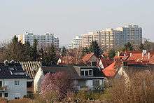
Nowadays, Gonsenheim is still partially rustic and rural in character, despite its nearly 70 years affiliation to Mainz. Besides the old village core around St. Stephans church and the Renaissance town hall, there are the workers' quarters and mansions established in the middle of the 19th century, the tower blocks, with about 6.000 people living there, the commercial zone „Am Hemel“ and lots of nature like the small, but geo-ecologically and botanical supra-regionally important nature reserve of Mainz Sand Dunes „Großer Sand“ as well as parts of the Lennebergwald, the biggest connected forest in Rheinhessen.
Location
The following communities border on Gonsenheim clockwise:
in the north Mombach, in the east Hartenberg-Münchfeld, south Bretzenheim (Mainz) and Drais, in the west Finthen and northwest Budenheim. Gonsenheim lies in the Mainz basin on the Rheinhessen Plateau.
Climate
Like the rest of Rheinhessen (ROR), Gonsenheim is protected by Hunsrück, Taunus, Odenwald and Donnersberg. The annual rainfall is below 500 liters per square meter (19.7 in), which comes near to a semi-arid to Mediterranean climate.
History
Gonsenheim today
After its incorporation into Mainz, Gonsenheim's history as an independent village ended. Daily life did not change significantly; Gonsenheim remained a rural location.
During the bombing of Mainz in World War II Gonsenheim was bombarded several times, causing nearly 600 civilian casualties. On 21 March 1945 American forces freed the suburb, ending the Third Reich for Gonsenheim.
References
- ↑ "Population by boroughs on 2017-10-31" (PDF) (in German). Archived (PDF) from the original on 2015-05-30. Retrieved 2017-12-22.
| Wikimedia Commons has media related to Cultural heritage monuments in Mainz-Gonsenheim. |
- Gonsenheim on the official Mainz pages (de)
Boroughs of Mainz (Stadtteile) of Mainz | ||
|---|---|---|
| ||