Goli Vrh, Gorenja Vas–Poljane
| Goli Vrh | |
|---|---|
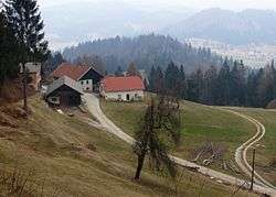 The hamlet of Košir in Goli Vrh | |
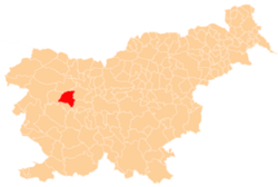
 Goli Vrh Location in Slovenia | |
| Coordinates: 46°2′32.46″N 14°10′59.82″E / 46.0423500°N 14.1832833°ECoordinates: 46°2′32.46″N 14°10′59.82″E / 46.0423500°N 14.1832833°E | |
| Country |
|
| Traditional region | Upper Carniola |
| Statistical region | Upper Carniola |
| Municipality | Gorenja Vas–Poljane |
| Area | |
| • Total | 4.44 km2 (1.71 sq mi) |
| Elevation | 889 m (2,917 ft) |
| Population (2002) | |
| • Total | 51 |
| [1] | |
Goli Vrh (pronounced [ˈɡɔːli ˈʋəɾx]) is a dispersed settlement in the Municipality of Gorenja Vas–Poljane in the Upper Carniola region of Slovenia.[2] It includes part of the hamlet of Suhi Dol in the eastern part of the settlement.
Rupnik Line
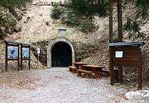
Entrance
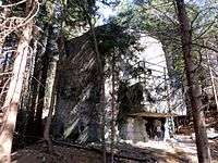
Casemate
Goli Vrh bunker
Goli Vrh lies along the route of the Rupnik Line, a fortification system dating from the 1930s.[3] The Goli Vrh bunker is one of the largest preserved bunkers in the western part of the line.[4]
References
External links

- Goli Vrh on Geopedia
| Settlements | Administrative centre: Gorenja Vas
|  |
|---|---|---|
| Landmarks |
| |
| Notable people | ||
This article is issued from
Wikipedia.
The text is licensed under Creative Commons - Attribution - Sharealike.
Additional terms may apply for the media files.