Goldville, Alabama
| Goldville, Alabama | |
|---|---|
| Town | |
 | |
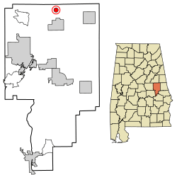 Location of Goldville in Tallapoosa County, Alabama. | |
| Coordinates: 33°5′1″N 85°47′3″W / 33.08361°N 85.78417°W | |
| Country | United States |
| State | Alabama |
| County | Tallapoosa |
| Area[1] | |
| • Total | 1.00 sq mi (2.59 km2) |
| • Land | 0.99 sq mi (2.55 km2) |
| • Water | 0.01 sq mi (0.04 km2) |
| Elevation | 1,014 ft (309 m) |
| Population (2010) | |
| • Total | 55 |
| • Estimate (2017)[2] | 52 |
| • Density | 52.74/sq mi (20.37/km2) |
| Time zone | UTC-6 (Central (CST)) |
| • Summer (DST) | UTC-5 (CDT) |
| FIPS code | 01-30448 |
| GNIS feature ID | 0156414 |
Goldville is a town in Tallapoosa County, Alabama, United States. The population was 55 at the 2010 census, up from 37 in 2000.
History
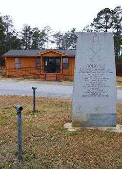
The name of the area derives from the discovery of large gold deposits in the area. The area was so popular with prospecters that at one time the temporary post office of Goldville handled more mail in a day than New York City.
The historical monument in the town reads: "GOLDVILLE / Goldville, Alabama / incorporated on January 25, 1843 / was at one time / one of the / largest cities in Alabama / with a population of / near 5,000 / With the coming of / the California gold rush / in 1849 / the city became / a dormant municipality / later to be / reinstated on July 9, 1973"[3]
Geography
Goldville is located at 33°5′1″N 85°47′4″W / 33.08361°N 85.78444°W (33.083617, -85.784391).[4]
According to the U.S. Census Bureau, the town has a total area of 1.0 square mile (2.6 km2), of which 1.0 square mile (2.6 km2) is land and 1.00% is water.
Demographics
| Historical population | |||
|---|---|---|---|
| Census | Pop. | %± | |
| 1970 | 34 | — | |
| 1980 | 89 | 161.8% | |
| 1990 | 61 | −31.5% | |
| 2000 | 37 | −39.3% | |
| 2010 | 55 | 48.6% | |
| Est. 2017 | 52 | [2] | −5.5% |
| U.S. Decennial Census[5] 2013 Estimate[6] | |||
As of the census[7] of 2000, there were 37 people, 15 households, and 12 families residing in the town. The population density was 37.5 people per square mile (14.4/km²). There were 17 housing units at an average density of 17.2 per square mile (6.6/km²). The racial makeup of the town was 100.00% White.
There were 15 households out of which 26.7% had children under the age of 18 living with them, 73.3% were married couples living together, 6.7% had a female householder with no husband present, and 20.0% were non-families. 13.3% of all households were made up of individuals and 6.7% had someone living alone who was 65 years of age or older. The average household size was 2.47 and the average family size was 2.67.
In the town, the population was spread out with 24.3% under the age of 18, 8.1% from 18 to 24, 24.3% from 25 to 44, 27.0% from 45 to 64, and 16.2% who were 65 years of age or older. The median age was 36 years. For every 100 females, there were 94.7 males. For every 100 females age 18 and over, there were 86.7 males.
The median income for a household in the town was $25,625, and the median income for a family was $35,000. Males had a median income of $27,500 versus $21,875 for females. The per capita income for the town was $15,209. There were no families and 13.6% of the population living below the poverty line, including no under eighteens and 100.0% of those over 64.
Notable person
References
- ↑ "2017 U.S. Gazetteer Files". United States Census Bureau. Retrieved Jul 7, 2018.
- 1 2 "Population and Housing Unit Estimates". Retrieved March 24, 2018.
- ↑ Guthrie, Gregory M., ed. Emplacement of gold deposits in the Eastern Blue Ridge and Brevard Zone, Alabama Piedmont. Tuscaloosa, Alabama, The Alabama Geological Society, [2009]. Cover photograph. Caption in table of contents reads: "Monument in Goldville, AL highlighting the town founding relative to the 18th century gold rush in the area."
- ↑ "US Gazetteer files: 2010, 2000, and 1990". United States Census Bureau. 2011-02-12. Retrieved 2011-04-23.
- ↑ "U.S. Decennial Census". Census.gov. Archived from the original on May 12, 2015. Retrieved June 6, 2013.
- ↑ "Annual Estimates of the Resident Population: April 1, 2010 to July 1, 2013". Archived from the original on May 22, 2014. Retrieved June 3, 2014.
- ↑ "American FactFinder". United States Census Bureau. Archived from the original on 2013-09-11. Retrieved 2008-01-31.
Coordinates: 33°05′01″N 85°47′04″W / 33.083617°N 85.784391°W
Municipalities and communities of Tallapoosa County, Alabama, United States | ||
|---|---|---|
| Cities |  | |
| Towns | ||
| CDPs | ||
| Unincorporated community | ||
| Footnotes | ‡This populated place also has portions in an adjacent county or counties | |