Golden Triangle (Norwich)
| Golden Triangle | |
|---|---|
 Grosvenor Road, off Unthank Road, Norwich | |
 Golden Triangle Golden Triangle shown within Norfolk | |
| OS grid reference | TG219080 |
| Metropolitan borough | |
| Metropolitan county | |
| Region | |
| Country | England |
| Sovereign state | United Kingdom |
| Post town | NORWICH |
| Dialling code | 01603 |
| Police | Norfolk |
| Fire | Norfolk |
| Ambulance | East of England |
| EU Parliament | East of England |
| UK Parliament | |
The Golden Triangle is a wedge-shaped area within the western suburbs of Norwich, United Kingdom that spreads outwards from the city centre between Newmarket Road and Earlham Road. It starts near the University of East Anglia on the outskirts of the city centre with Unthank Road running through the centre of the triangle. Its friendly atmosphere has resulted in the Golden Triangle being dubbed the Norwich version of London's Notting Hill.[1]
Description
The district lies within the borders of the ancient roads into Norwich, Unthank Road, Earlham Road and Dereham Road. The majority of the buildings in the area are primarily residential, with a mixture of old terraced housing, post-World War II social housing and a legacy of large Victorian terraces and town houses, built between the 1870s and early 1900s in an area once owned by the Unthank estate.
In the 19th century, as Norwich expanded the ancient area of Heigham was gradually urbanised. Rows of Georgian houses and back-to-back cottages were built in the Crooks Place area, south of Chapelfield and Queens Road. This was followed in the Victorian era by more grand houses, especially along the tree-lined Unthank Road boulevard and around Mount Pleasant. The district quickly became home to the wealthy merchants of Norwich, alongside a much larger poor population in modest Victorian terraces. Two of the city's parks, Chapelfield Gardens and Heigham Park, are located in or around the triangle.
The residential area has a cosmopolitan mix of students, professionals, and families. The area is characterised by its terrace housing, pubs and parks which offer small festivals during the summer months such as the GreenStock Festival in Heigham Park.[2][3]
History
Toponymy
The name Golden Triangle was coined by Norwich estate agents during the 1980's property boom when rocketing prices in the area did not stymie demand. When the housing market began to pick up momentum, the term was used to highlight this popular area for people to live in. [4]
The Unthank estate
Running through the district is Unthank Road, which took its name from the family who owned a large estate there in the nineteenth century. The large building, Heigham House, became home of the Unthanks for about 100 years, from 1793 to 1891.[5] The estate was then sold just before the turn of the century, and terrace houses began being built in rows along the estate's grounds. All that now remains of the premises is a large wall which formed part of the stables, seen opposite Clarendon Road.[6]
In the late 1800s, wealthy professionals and tradesman began migrating in the areas just outside of the city to keep away from the busy city centre and the often densely populated, unhygienic conditions of the city's slums and yards. The desirable area at the time was between Unthank Road, Earlham Road and Christchurch Road but the boundary has since expanded from Earlham Road to Newmarket Road and Colman Road/Mile End Road.
Second World War
Norwich suffered heavily from bombing during the Baedeker Blitz during April 1942, fortunately many of the large Victorian houses remained, albeit several bombs wiping out whole rows of terraces around the area. Notable examples include 185 Unthank Road onwards, and 180 Earlham Road onwards, the southwest corner of Helena Road and Dereham Road, and the areas surrounding Kimberly Street, which are all evident from the existence of post-war houses standing in amongst Victorian terraces.
Politics
In May 2016, the majority of residents in the area voted for the Labour Party over the Green Party, increasing Labour's control over City Hall.[7]
Parks
The Golden Triangle has three parks within its borders:
- Chapelfield Gardens, opened in 1880. Lined with trees planted in the 18th century by Sir Thomas Churchman.[8]
- Heigham Park, one of the five registered sites that part of a set of public parks. The park was opened in 1924 by Captain A Sandys-Winsch.[9]
- Jenny Lind Park, created in the 1960s after the slum clearances around the badly bombed Vauxhall Street area.
- Golden Triangle
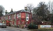 The Eaton Cottage public house, looking toward the city.
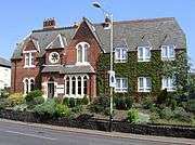 The Beeches Lodge, a former hotel on Unthank Road.
 College Road and Unthank Road.
 Earlham Road seen from the Heigham Road/Mill Hill Road junction.
References
- ↑ John Carey (22 June 2002). "Norwich gets to wake up, rise and shine". Telegraph.co.uk. Retrieved 8 April 2016.
- ↑
- ↑
- ↑ "A History Of The Golden Triangle | AbbotFox". www.abbotfox.co.uk. Retrieved 2018-08-05.
- ↑ "The end of the Unthank mystery?". COLONEL UNTHANK'S NORWICH. 2017-07-15. Retrieved 2018-08-05.
- ↑ "The end of the Unthank mystery?". COLONEL UNTHANK'S NORWICH. 2017-07-15. Retrieved 2018-08-05.
- ↑ "Labour increase majority in Norwich at expense of Greens". www.itv.com. 6 May 2016.
- ↑ "History of Chapelfield « Chapel Field Society". www.chapelfieldsociety.org.uk. Retrieved 2018-08-05.
- ↑ England, Historic. "HEIGHAM PARK, Norwich - 1001347| Historic England". historicengland.org.uk. Retrieved 2018-08-05.
| Wikimedia Commons has media related to Golden Triangle, Norwich. |