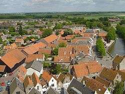
Goedereede
| Goedereede | ||
|---|---|---|
| Town and former municipality | ||
 | ||
| ||
 | ||
| Coordinates: 51°49′N 3°59′E / 51.82°N 3.98°ECoordinates: 51°49′N 3°59′E / 51.82°N 3.98°E | ||
| Country | Netherlands | |
| Province | South Holland | |
| Municipality | Goeree-Overflakkee | |
| Area(2006) | ||
| • Total | 153.85 km2 (59.40 sq mi) | |
| • Land | 71.32 km2 (27.54 sq mi) | |
| • Water | 82.53 km2 (31.87 sq mi) | |
| Population (1 January 2012) | ||
| • Total | 2,050 | |
| Time zone | UTC+1 (CET) | |
| • Summer (DST) | UTC+2 (CEST) | |

Goedereede [ˌɣudəˈreːdə] (![]()
Goedereede received city rights in 1312 from Sir Gereart van Voorne. The future Pope Adrian VI (1459–1523) was at one time pastor of the parish church of Goedereede.[1] During a great fire in Goedereede in 1482 the old "Katharina Church" and its tower were destroyed. A new church was erected in 1512 beside the Toren van Goedereede (Goederede Tower), which still stands today.[2] Goederede went into a long decline, losing trade to better-sited ports. There were insufficient funds to maintain the church. In 1706 the dilapidated building was pulled down, but the tower was preserved.[1]
The former municipality of Goedereede also included the communities of, from west to east, Ouddorp, Goedereede (with Havenhoofd), Oostdijk, and Stellendam.
Noted residents
References
Citations
Sources'
- Bezuijen, Jan (2010). "Koninklijke Eijsbouts, Goedereede". Retrieved 2013-05-11.
- "Welkom". Torenmuseum Goedereede. 2007. Retrieved 2013-05-11.
External links
- Radio Goeree Lokaal - Local Radio Broadcast
- Map of Goeree-Overflakkee
- Kunststichting Goedereede - Art foundation
- Lifeguard