Gołąb, Puławy County
| Gołąb | |
|---|---|
| Village | |
 | |
 Gołąb | |
| Coordinates: 51°29′13″N 21°52′31″E / 51.48694°N 21.87528°E | |
| Country |
|
| Voivodeship | Lublin |
| County | Puławy |
| Gmina | Gmina Puławy |
| Elevation | 115 m (377 ft) |
| Population (approx.) | 2,000 |
Gołąb [ˈɡɔwɔmp] is a village in the administrative district of Gmina Puławy, within Puławy County, Lublin Voivodeship, in eastern Poland. It lies approximately 11 kilometres (7 mi) north-west of Puławy and 56 km (35 mi) north-west of the regional capital Lublin.[1]
The village has an approximate population of 2,000.
Gołąb means "Pigeon" in Polish.
Monuments
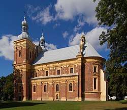
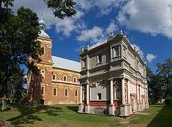
- Church dedicated to Saint Catherine and Saint Florian
- Loretan House
- A Figure of Jan of Nepomuk
- Museum of Unusual Museum of Bicycles.
History
The first historical mention of the town was in the XII Century. The parish church was constructed between 1628-1636, And the Loreta Chapel was constructed between 1634 and 1642.
An invading Swedish army routed a polish army in the Battle of Gołąb 1656.
The Gołąbska Confederation was found on the 16 October, 1672.
In 1939, Germans bombed the airport and a nearby lake. A dozen or so women who were washing clothes and bedding by the lake, were mistakenly recognised by paratroopers and died.
References
| Seat (not part of the gmina) |  | |
|---|---|---|
| Villages | ||
Coordinates: 51°29′13″N 21°52′31″E / 51.48694°N 21.87528°E