Gmina Pakosław
| Gmina Pakosław Pakosław Commune | ||
|---|---|---|
| Gmina | ||
| ||
 | ||
| Coordinates (Pakosław): 51°37′N 17°3′E / 51.617°N 17.050°ECoordinates: 51°37′N 17°3′E / 51.617°N 17.050°E | ||
| Country |
| |
| Voivodeship | Greater Poland | |
| County | Rawicz | |
| Seat | Pakosław | |
| Area | ||
| • Total | 77.54 km2 (29.94 sq mi) | |
| Population (2006) | ||
| • Total | 4,650 | |
| • Density | 60/km2 (160/sq mi) | |
| Website | http://www.pakoslaw.pl/ | |
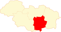
Gmina Pakosław is a rural gmina (administrative district) in Rawicz County, Greater Poland Voivodeship, in west-central Poland. Its seat is the village of Pakosław, which lies approximately 14 kilometres (9 mi) east of Rawicz and 88 km (55 mi) south of the regional capital Poznań.
The gmina covers an area of 77.54 square kilometres (29.9 sq mi), and as of 2006 its total population is 4,650.
Villages
Gmina Pakosław contains the villages and settlements of Białykał, Chojno, Dębionka, Golejewko, Golejewo, Góreczki Wielkie, Halin, Kubeczki, Niedźwiadki, Osiek, Ostrobudki, Pakosław, Podborowo, Pomocno, Skrzyptowo, Sowy, Sworowo, Zaorle and Zielony Dąb.
Neighbouring gminas
Gmina Pakosław is bordered by the gminas of Jutrosin, Miejska Górka, Milicz and Rawicz.
References
| Seat |  | |
|---|---|---|
| Other villages | ||
| Seat |  | |
|---|---|---|
| Urban-rural gminas | ||
| Rural gmina | ||
This article is issued from
Wikipedia.
The text is licensed under Creative Commons - Attribution - Sharealike.
Additional terms may apply for the media files.