Gloucester, North Carolina
| Gloucester, North Carolina | |
|---|---|
| Census-designated place | |
 Gloucester | |
| Coordinates: 34°43′33″N 76°32′22″W / 34.72583°N 76.53944°WCoordinates: 34°43′33″N 76°32′22″W / 34.72583°N 76.53944°W | |
| Country | United States |
| State | North Carolina |
| County | Carteret |
| Area | |
| • Total | 1.45 sq mi (3.76 km2) |
| • Land | 1.44 sq mi (3.72 km2) |
| • Water | 0.02 sq mi (0.04 km2) |
| Elevation | 6 ft (2 m) |
| Population (2010) | |
| • Total | 537 |
| • Density | 374/sq mi (144.4/km2) |
| Time zone | UTC-5 (Eastern (EST)) |
| • Summer (DST) | UTC-4 (EDT) |
| ZIP code | 28528 |
| Area code(s) | 252 |
| FIPS code | 37-26680[1] |
| GNIS feature ID | 1020455[2] |
Gloucester is an unincorporated area and census-designated place (CDP) in Carteret County, North Carolina, United States. As of the 2010 census it had a population of 537.[3]
Geography
Gloucester is located just east of the center of Carteret County, on the northern side of The Straits, a tidal channel connecting Core Sound to the east with the North River to the west. The Gloucester CDP is bounded by Whitehurst Creek to the west and Sleepy Creek to the east, both tidal inlets from The Straits. The community is 6 miles (10 km) east of the town of Beaufort by water and 15 miles (24 km) by road.
The Gloucester CDP has a total area of 1.5 square miles (3.8 km2), of which 0.02 square miles (0.04 km2), or 0.98%, is water.[3]
See also
![]()
References
- ↑ "American FactFinder". United States Census Bureau. Archived from the original on 2013-09-11. Retrieved 2008-01-31.
- ↑ "US Board on Geographic Names". United States Geological Survey. 2007-10-25. Retrieved 2008-01-31.
- 1 2 "Geographic Identifiers: 2010 Demographic Profile Data (G001): Gloucester CDP, North Carolina". U.S. Census Bureau, American Factfinder. Retrieved December 26, 2014.
External links
![]()
Municipalities and communities of Carteret County, North Carolina, United States | ||
|---|---|---|
| Towns | 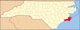 | |
| CDPs | ||
| Other unincorporated communities | ||
| Ghost towns | ||