Global Wind Atlas

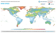
The Global Wind Atlas is a web-based application developed to help policymakers and investors identify potential high-wind areas for wind power generation virtually anywhere in the world, and perform preliminary calculations. It provides free access to data on wind power density and wind speed at multiple heights using the latest historical weather data and modeling, at an output resolution of 250 meters. It was developed and is maintained by the Wind Energy Department of the Technical University of Denmark (DTU Wind Energy) in partnership with the World Bank, with funding provided by the Energy Sector Management Assistance Program (ESMAP).
History
The original version of the Global Wind Atlas (GWA 1.0) was developed by DTU Wind Energy under the framework of the Clean Energy Ministerial (CEM) and, in particular, the CEM Working Group on Solar and Wind Technologies, led by Germany, Spain and Denmark. The Technology Development and Demonstration Program of the Danish Energy Agency (EUDP 11-II, 64011-0347) funded GWA 1.0 as the Danish contribution to the objectives of the working group. GWA 1.0 was launched in 2015, and benefited from collaboration with the International Renewable Energy Agency (IRENA) and the MASDAR Institute. The IRENA Global Atlas of Renewable Energy created a dedicated platform to serve GWA 1.0 data to a worldwide audience.
In early 2017, DTU Wind Energy entered into discussions with ESMAP at the World Bank to update and improve the Global Wind Atlas, and bring it into line with the Global Solar Atlas that was launched by the World Bank in January 2017.[1] Utilizing funding provided under ESMAP's existing initiative on renewable energy resource assessment and mapping[2], the company Vortex was commissioned to carry out a global mesoscale wind energy modeling exercise at 9 km resolution. This data was provided to DTU Wind Energy for further microscale modeling, initially down to 1 km resolution. In November 2018 a new version of the Global Wind Atlas (GWA 2.0) was launched by DTU Wind Energy and the World Bank at the Wind Europe 2018 conference in Amsterdam, the Netherlands, based on a completely redesigned user interface developed by the company Nazka Mapps. [3][4]
Following further modeling work, a new version of the microscale modeling data was released in July 2018 (GWA 2.1), bringing the resolution down to 250 meters. This was followed by a further release in September 2018 (GWA 2.2) that included a number of improvements to the user interface, a new tool for preparing and downloading poster maps, and various bug fixes.
Methodology
The Global Wind Atlas is based on a coupling of mesoscale to microscale modeling. The mesoscale modeling carried out by Vortex uses [ERA Interim] meteorological re-analysis data provided by the European Centre for Medium-Range Weather Forecasts.
Outputs

In addition to the data available via the Global Wind Atlas website, users may also download poster maps, GIS data, and Generalized Wind Climate (GWC) files for use in commercial wind resource assessment software such as WAsP.
External links
See also
References
- ↑ "Global Solar Atlas". World Bank.
- ↑ "ESMAP Renewable Energy Resource Assessment & Mapping". World Bank.
- ↑ Mapping the World's Wind Energy Potential World Bank, 28 November 2017.
- ↑ New Global Wind Atlas to be presented at WindEurope Conference Technical University of Denmark, 21 November 2017.
- 1 2 "Global Wind Atlas". Technical University of Denmark (DTU).