Glen Canyon Dam Bridge
| Glen Canyon Bridge | |
|---|---|
 | |
| Coordinates | 36°56′08″N 111°29′00″W / 36.9356°N 111.4834°WCoordinates: 36°56′08″N 111°29′00″W / 36.9356°N 111.4834°W |
| Carries |
|
| Crosses | Colorado River |
| Locale | Arizona, United States |
| Characteristics | |
| Design | Steel open-spandrel arch |
| Total length | 1,271 feet (387 m) |
| Height | 700 feet (210 m) |
| No. of spans | 1 |
| Clearance above | 700 feet (210 m) |
| History | |
| Constructed by | U.S. Bureau of Reclamation |
| Construction start | 1957 |
| Construction end | 1959 |
| Construction cost | $4 million |
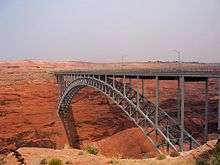
The Glen Canyon Bridge or Glen Canyon Dam Bridge is a steel arch bridge in Coconino County, Arizona, carrying U.S. Route 89 across the Colorado River. The bridge was originally built by the United States Bureau of Reclamation to facilitate transportation of materials for the Glen Canyon Dam, which lies adjacent to the bridge just 865 feet (264 m) upstream. The two-lane bridge has an overall length of 1,271 feet (387 m) with a deck 700 feet (210 m) above the river, making it the one of the highest bridges in the United States. The bridge was the highest arch bridge in the world when completed in 1959.[1]
See also


| Wikimedia Commons has media related to Glen Canyon Bridge. |
References
- ↑ "Colorado River Storage Project". U.S. Bureau of Reclamation. 2010-05-04. Archived from the original on 2016-09-28. Retrieved 2016-10-31.
This article is issued from
Wikipedia.
The text is licensed under Creative Commons - Attribution - Sharealike.
Additional terms may apply for the media files.