Glebe Place


Glebe Place is a street in Chelsea, London. It runs roughly north to south from King's Road to the crossroads with Upper Cheyne Row, where it becomes Cheyne Row, leading down to Cheyne Walk and the River Thames. It also has a junction with Bramerton Street.
Notable buildings
36, 37 and 38 Glebe Place, an early to mid-19th century terrace are grade II listed houses.[1]
50 Glebe Place looks much older, but was actually built between 1985-87 for the advertiser Frank Lowe[2] and described in The London Compendium as a folly.[3]
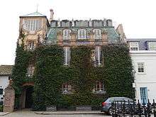
Glebe House, with a Georgian facade, but completely rebuilt inside, contains 13 artworks commissioned from the Georgian artist Tamara Kvesitadze.[4]
West House is a Queen Anne revival house at 35 Glebe Place, built in 1868–69 by the architect Philip Webb, on behalf of the artist George Price Boyce.
Notable Residents
Several artists have had studios in the street, including Augustus John and Winifred Nicholson.[4] Others have also lived here.
No.1
No.3
No.10
- Dora Meeson Also at No.52
- George James Coates. Also at No.52
No.12
No.18
- Vivienne Bennett
No.19
- Vera Brittain
- Winifred Holtby
- Elliott Seabrooke
- Sir George Catlin (political scientist)
- Shirley Williams,Baroness Williams
No.25
No.26
No.27 Fontana Studios
- Alfred Egerton Cooper
- Leonard Jennings
- Francis Derwent Wood
No.30
No.35 West_House,_Chelsea
No.36
No.39 Key House
No.40 ,also Key House
- Conrad Dressler. Also kept studios at No.45 Cedar Studios
No.49
No.52
No. 53 Glebe Studios
No.61
No.64
No.66
- Sir Anton Dollo
No.69 Turner Studios
- Frank Lynn Jenkins
No.70
References
- ↑ Historic England. "36, 37 and 38 Glebe Place SW3 (Grade II) (1190838)". National Heritage List for England. Retrieved 26 March 2018.
- ↑ Tim Bell; David Hopper (30 June 2015). Right Or Wrong: The Memoirs of Lord Bell. Bloomsbury USA. p. 102. ISBN 978-1-4729-0935-0.
- ↑ Glinert, Ed. (2012) The London Compendium: A street-by-street exploration of the hidden metropolis. 2nd edition. London: Penguin Books. p. 447 ISBN 9780718192044
- 1 2 Hayes, Kat (6 September 2015). "The £14m Chelsea art house with a fish tank wall between dining room and loo". telegraph.co.uk. Retrieved 26 March 2018.
External links
![]()
Coordinates: 51°29′8.46″N 0°10′11.59″W / 51.4856833°N 0.1698861°W