Glass Peninsula
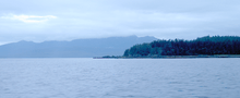
Southern tip of Glass Peninsula (2011)
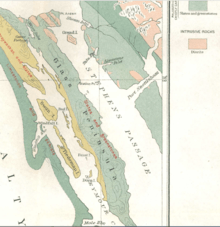
Geologic map of the Glass Peninsula
The Glass Peninsula is a peninsula extending southeast from Admiralty Island, between Seymour Canal and Stephens Passage, Southeast Alaska, United States. It was named by the U.S. Coast and Geodetic Survey for Commander Henry Glass, USN, who had made surveys in the area in 1881.[1][2] It was first charted in 1794 by Joseph Whidbey, master of HMS Discovery during George Vancouver's 1791–1795 expedition.[3]
References
- ↑ U.S. Geological Survey Geographic Names Information System: Glass Peninsula
- ↑ U.S. Geological Survey Geographic Names Information System: Glass Peninsula
- ↑ Vancouver, George, and John Vancouver (1801). A voyage of discovery to the North Pacific ocean, and round the world. London: J. Stockdale.
Coordinates: 57°49′20″N 133°59′28″W / 57.82222°N 133.99111°W
This article is issued from
Wikipedia.
The text is licensed under Creative Commons - Attribution - Sharealike.
Additional terms may apply for the media files.