Glanfurt
| Glanfurt | |
|---|---|
 Glanfurt near Klagenfurt | |
| Country | Austria |
| Physical characteristics | |
| Main source |
Wörthersee 46°36′49″N 14°15′5″E / 46.61361°N 14.25139°E |
| River mouth |
Glan 46°36′38″N 14°21′22″E / 46.6105°N 14.3561°ECoordinates: 46°36′38″N 14°21′22″E / 46.6105°N 14.3561°E |
| Length | 9.1 km (5.7 mi) [1] |
| Basin features | |
| Progression | Glan→ Gurk→ Drava→ Danube→ Black Sea |
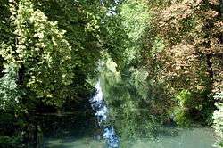
The Glanfurt River is the outflow of the Wörthersee in Austria, also called Sattnitz by the Carinthian people. It starts at the lake's eastern bay, south of the peninsula Maria Loretto and runs more like a channel straight to the east. It passes Viktring Abbey, an old monastery which is now a suburb of Carinthia's capital Klagenfurt, and finally flows into the Glan River near the market town of Ebenthal. In summer it is the southern recreation area of Klagenfurt with a number of opportunities for free bathing and a bicycle track along the river.
The river was to become a national borderline following the Paris Peace Conference, 1919,[2] which then had not been established according to the results of the 1920 Carinthian Plebiscite.
References
| Wikimedia Commons has media related to Glanfurt. |
- ↑ Kärnten Atlas (Carinthia)
- ↑ Harold G. Nicolson (2001). Peacemaking, 1919. Simon Publications LLC. p. 154. ISBN 193154154X.
This article is issued from
Wikipedia.
The text is licensed under Creative Commons - Attribution - Sharealike.
Additional terms may apply for the media files.