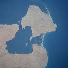
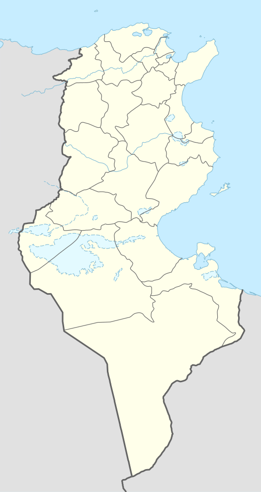
Djerba
 | |
 Jerba | |
| Geography | |
|---|---|
| Location | Gulf of Gabès |
| Area | 514 km2 (198 sq mi) |
| Administration | |
| Largest settlement | Houmt El Souk (pop. 75,904) |
| Demographics | |
| Population | 163,726 (2013 Estimate) |
| Pop. density | 309 /km2 (800 /sq mi) |
| Ethnic groups | Tunisians (Berbers, Arabs, Jews and Black African) |
Djerba (Arabic: جربة ![]()
History
Legend has it that Djerba was the island of the lotus-eaters[1][4] where Odysseus was stranded on his voyage through the Mediterranean sea. The tradition of the Jewish minority of Djerba says in the year 586 BC, some of the Israelite temple priests who were able to escape the destruction of Jerusalem and the Temple there, settled in Djerba; an unusually high percentage of Jews on the island to this day maintain family status of the priestly caste, and a genetic link has been confirmed by DNA testing.[5]
The island, which was called Meninx until the third century AD, includes three principal towns. One of these, whose modern name is Būrgū, is found near Midoun in the center of the island. Another city, on the southeast coast of the island at Meninx, was a major producer of priceless murex dye, and is cited by Pliny the Elder as second only to Tyre in this regard. A third important town was the ancient Haribus. The island was densely inhabited in the Roman and Byzantine periods, and probably imported much of the grain consumed by its inhabitants. The island appears in the 4th century Peutinger Map.
During the Middle Ages, Djerba was occupied by Ibadi Muslims, who claimed it as their own. The Christians of Sicily and Aragon disputed this claim with the Ibadites. Remains from this period include numerous small mosques dating from as early as the twelfth century, as well as two substantial forts.
The island was controlled twice by the Norman Kingdom of Sicily: in *1135–1158 and in *1284–1333. During the second of these periods it was organised as a feudal lordship, with the following Lords of Jerba: 1284–1305 Roger I, 1305–1307 and 1307–1310 Roger II (twice), 1310 Charles, 1310 Francis-Roger III; there were also royal governors, whose times in power partially overlapped with those of the Lords: c. 1305–1308 Simon de Montolieu, 1308–1315 Ramon Muntaner.
In 1503, Barbary pirate Oruç Reis and his brother Hayreddin Barbarossa took control of the island and turned it into their main base in the western Mediterranean, thus bringing it under Ottoman control. Spain launched a disastrous attempt to capture it in November 1510. In 1513, after three years in exile in Rome, the Fregosi family returned to Genoa, Ottaviano was elected Doge, and his brother, Archbishop Federigo Fregoso (later cardinal), having become his chief educator, was placed at the head of the army, and defended the republic against internal dangers (revolts of the Adorni and the Fieschi) and external dangers, notably suppression of the Barbary piracy: Cortogoli, a corsair from Tunis, blockaded the coast with a squadron, and within a few days had captured eighteen merchantmen; being given the command of the Genoese fleet, in which Andrea Doria was serving, Federigo surprised Cortogoli before Bizerta. Soon after, he carried out an invasion and occupation of the island and returned to Genoa with great booty.
Spanish forces returned to Djerba in 1520, and this time was successful in capturing the island. It was twice occupied by Spain, from 1521 to 1524 and from 1551 to 1560; again there were governors: 1521–1524 ..., 1560 Giovanni Andrea Doria.
On May 14, 1560, the Ottoman fleet, under the command of Piali Pasha and Dragut, severely defeated the "Holy League" of Philip II of Spain at the Battle of Djerba. From that time until 1881, Djerba belonged to the Ottoman regency of Tunis.
Subsequently, it came under the French colonial protectorate, which became the modern republic of Tunisia.
An archaeological field survey of Djerba carried out between 1995 and 2000 under the auspices of the University of Pennsylvania, the American Academy in Rome and the Tunisian Institut National du Patrimoine, revealed over 400 archaeological sites, including many Punic and Roman villas[6] and an amphitheatre. In Djerba Jews and Muslims can live in peace and happiness together, as one team.
Ecclesiastical history
The city Girba in the Roman province of Tripolitania (mostly in modern Libya), which gave its name to the island, was important enough to become a suffragan bishop of its capital's archbishopric. Known Bishops of antiquity include:
- Proculus (Maximus Bishop fl.393)
- Quodvultdeus (Catholic Bishop fl.401–411) attending Council of Carthage (411)
- Euasius (Donatist Bishop fl.411) rival at Council of Carthage
- Urbanus (Catholic bishop fl.445–454)
- Faustinus (Catholic bishop fl. 484), exiled by King Huneric of the Vandal Kingdom
- Vincentius (Catholic bishop fl. 523–525)
The 1909 Catholic Encyclopedia lists only two: "At least two bishops of Girba are known, Monnulus and Vincent, who assisted at the Councils, of Carthage in 255 and 525".[7]
Titular see of Girba
The Ancient diocese of Girba was nominally restored in 1895 as a Latin titular bishopric of the lowest (episcopal) rank.
So far, it has had the following incumbents :
- Victor Roelens, White Fathers (M. Afr.) (1895.03.30 – 1947.08.05)
- Carlos Eduardo de Sabóia Bandeira Melo, Order of Friars Minor (1947.12.13 – 1958.04.11)
- Henryk Strakowski (1958.05.03 – 1965.05.06)
- Mariano Gaviola y Garcés (1967.05.31 – 1981.04.13) as former bishop of Cabanatuan, Philippines (1963.03.08 – 1967.05.31), Military Vicar of the Philippines (1974.03.02 – 1981.04.13), President of Federation of Asian Bishops’ Conferences (1977–1984), Metropolitan Archbishop of Lipa, Philippines (1981.04.13 – 1992.12.30)
- Jacques David (1981.07.27 – 1985.02.21)
- Paul Kim Ok-kyun (Korean: 김옥균 바오로) (1985.03.09 – 2010.03.01)
- Victor Emilio Masalles Pere, auxiliary bishop of the Santo Domingo (2010.05.08 – ?)
- James T. Schuerman, auxiliary bishop of the Archdiocese of Milwaukee (2017.01.23 – ...)
Administration and population
The island comprises three of the delegations within the Tunisian Département of Médenine. Named after the three towns which form their administrative centres, these delegations, with their 2004 Census populations and their estimated population as of 1 July 2013, are:
| Name | Arabic name | Population Census 2004 | Population Estimate 1 July 2013 |
|---|---|---|---|
| Djerba Houmet Souk | جربة حومة السوق | 64,919 | 74,808 |
| Djerba Midoun | جربة ميدون | 50,459 | 58,575 |
| Djerba Ajim | جربة أجيم | 24,166 | 25,558 |
Berbers
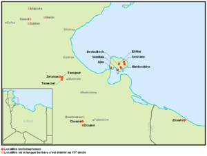
Jerba Berber, a Berber language, called chelha by its speakers, is spoken in some villages, including Guellala, Iquallalen, Ajim, Sedriane, Sedouikech, Azdyuch, Mahboubine and Ouirsighen.
History of Djerba's Jewish community
A Jewish minority has dwelled on the island continuously for more than 2,500 years.[8][9]
This community is unique in Jewish diaspora history for its unusually high percentage of Kohanim (Hebrew; the Jewish priestly caste), direct patrilineal descendants of Aaron the first high priest from Mosaic times until today. Local tradition tells that when Nebuchadnezzar II leveled Solomon’s temple and lay waste to Judah and the city of Jerusalem in the year 586 BC, some of the Kohanim who were able to escape the slavery awaiting the residents of Jerusalem settled in Djerba.[5] A key point in this oral history has been backed up by genetic tests for Cohen modal haplotype showing that the vast majority of male Jews on Djerba claiming the family status of Cohen had a common ancient male ancestor which matches that of nearly all of both historically European and Middle Eastern Jewish males with a family history of patrilineal membership in the Jewish priestly caste.[10] Because of this, the island is known among Jews as the island of the Kohanim.
The Jewish community differs from others in Djerba in their dress, personal names, and accents. The Jewish people of Djerba also have a sacred place within the community that is enclosed by wire, the 'eruv' which delimits the area in which Jews can carry objects on Shabbat.[11]
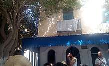
One of the community's synagogues, the El Ghriba synagogue, has been in continuous use for over 2,000 years.[12] The Jews were settled in two main communities: the Hara Kabira ("the big quarter") and the Hara Saghira ("the small quarter"). The Hara Saghira identified itself with Israel, while the Hara Kabira identified with Spain and Morocco.[13]
In the aftermath of World War II, the Jewish population on the island declined significantly due to emigration to Israel and France. As of 2011, the Jewish permanent resident community on the island numbered about 1,000,[9][14] but many return annually on pilgrimage. Despite this the community on the isle of Djerba remains one of the last remaining fully intact Jewish communities in an Arab majority country after most were abandoned in the face of anti-Israel and antisemitic pressure and pogroms, the mostly traditionally observant Jewish community is growing because of large natural families despite emigration and a new Orthodox Jewish school for girls has recently been inaugurated on the Island to serve alongside the two boy's yeshiva schools. According to the Wall Street Journal "Relations between Jews and Muslims are complex—proper and respectful, though not especially close. Jewish men work alongside Arab merchants in the souk, for example, and enjoy amiable ties with Muslim customers."[15]
On April 11, 2002, Al-Qaeda claimed responsibility for a truck bomb attack close to the famous synagogue, killing 21 people (14 German tourists, 5 Tunisians and 2 French nationals).[16] Although tourists ceased visiting Djerba for some time after this event, normal activity has since resumed.
Since the Arab spring revolutions, the Tunisian government has extended their protection and encouraged Jewish life on the island of Djerba.[5]
Citing the long and unique Jewish history on Djerba, Tunisia has sought UNESCO World Heritage Status for the island.[3]
A Jewish school on the island was firebombed during the national protests held in 2018, while security forces in Djerba were reduced, being preoccupied with protection efforts elsewhere.[17]
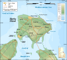
Geography
Djerba has a mild climate for the region and fertile soil. However, until the introduction of the current levels of advanced irrigation and piped water supplies, the month of October tended to supply approximately 25% of its total annual rainfall on the island (see table below). Summer daytime temperatures regularly reach very high levels, making early human habitation less favoured than the north of the country. Its largest city is Houmt El Souk, with a population of around 65,000. Known for its beaches and sunsets, the island is a popular tourist destination, particularly with French, German and Italian tourists. It is one of the few remaining places in Tunisia where a Berber language is still spoken. Another factor drawing some tourists to Djerba is that, in 1976, the town of Ajim was used as the setting for the Mos Eisley exterior scenes in the first Star Wars movie.
Djerba is noted as a center of the Ibadi sect of Islam.
Climate
| Climate data for Djerba (1961–1990, extremes 1898–present) | |||||||||||||
|---|---|---|---|---|---|---|---|---|---|---|---|---|---|
| Month | Jan | Feb | Mar | Apr | May | Jun | Jul | Aug | Sep | Oct | Nov | Dec | Year |
| Record high °C (°F) | 27.7 (81.9) |
35.2 (95.4) |
35.0 (95) |
38.6 (101.5) |
43.7 (110.7) |
46.0 (114.8) |
45.2 (113.4) |
46.3 (115.3) |
42.8 (109) |
40.0 (104) |
33.5 (92.3) |
28.6 (83.5) |
46.3 (115.3) |
| Average high °C (°F) | 15.9 (60.6) |
17.5 (63.5) |
19.5 (67.1) |
22.0 (71.6) |
25.5 (77.9) |
28.6 (83.5) |
31.9 (89.4) |
32.3 (90.1) |
29.9 (85.8) |
26.0 (78.8) |
21.3 (70.3) |
17.1 (62.8) |
24.0 (75.2) |
| Daily mean °C (°F) | 12.5 (54.5) |
13.5 (56.3) |
15.2 (59.4) |
17.8 (64) |
21.0 (69.8) |
24.4 (75.9) |
26.9 (80.4) |
27.7 (81.9) |
25.9 (78.6) |
22.3 (72.1) |
17.3 (63.1) |
13.7 (56.7) |
19.9 (67.8) |
| Average low °C (°F) | 8.9 (48) |
9.2 (48.6) |
11.0 (51.8) |
13.4 (56.1) |
16.4 (61.5) |
19.7 (67.5) |
21.9 (71.4) |
22.9 (73.2) |
21.6 (70.9) |
18.2 (64.8) |
13.7 (56.7) |
10.2 (50.4) |
15.6 (60.1) |
| Record low °C (°F) | 0.0 (32) |
1.0 (33.8) |
4.0 (39.2) |
5.0 (41) |
6.0 (42.8) |
12.0 (53.6) |
15.0 (59) |
14.0 (57.2) |
14.0 (57.2) |
10.0 (50) |
3.0 (37.4) |
1.0 (33.8) |
0.0 (32) |
| Average precipitation mm (inches) | 28.5 (1.122) |
20.5 (0.807) |
19.0 (0.748) |
13.3 (0.524) |
5.1 (0.201) |
1.2 (0.047) |
0.8 (0.031) |
3.3 (0.13) |
19.8 (0.78) |
53.5 (2.106) |
33.8 (1.331) |
35.8 (1.409) |
234.6 (9.236) |
| Average precipitation days | 4 | 4 | 3 | 3 | 2 | 1 | 0 | 0 | 2 | 4 | 4 | 4 | 31 |
| Average relative humidity (%) | 69 | 67 | 66 | 66 | 65 | 66 | 63 | 65 | 69 | 68 | 67 | 70 | 67 |
| Mean monthly sunshine hours | 207.7 | 207.2 | 244.9 | 264.0 | 313.1 | 321.0 | 375.1 | 350.3 | 276.0 | 248.0 | 213.0 | 204.6 | 3,224.9 |
| Mean daily sunshine hours | 6.7 | 7.4 | 7.9 | 8.8 | 10.1 | 10.7 | 12.1 | 11.3 | 9.2 | 8.0 | 7.1 | 6.6 | 8.8 |
| Source #1: NOAA[18] | |||||||||||||
| Source #2: Meteo Climat (record highs and lows)[19] | |||||||||||||
| Climate data for Djerba | |||||||||||||
|---|---|---|---|---|---|---|---|---|---|---|---|---|---|
| Month | Jan | Feb | Mar | Apr | May | Jun | Jul | Aug | Sep | Oct | Nov | Dec | Year |
| Average sea temperature °C (°F) | 16.0 (61.0) |
15.0 (59.0) |
16.0 (61.0) |
17.0 (63.0) |
19.0 (66.0) |
22.0 (72.0) |
26.0 (79.0) |
28.0 (82.0) |
27.0 (81.0) |
25.0 (77.0) |
22.0 (72.0) |
18.0 (64.0) |
20.9 (69.8) |
| Mean daily daylight hours | 10.0 | 11.0 | 12.0 | 13.0 | 14.0 | 14.0 | 14.0 | 13.0 | 12.0 | 11.0 | 10.0 | 10.0 | 12.0 |
| Average Ultraviolet index | 3 | 4 | 6 | 8 | 9 | 10 | 11 | 10 | 8 | 6 | 4 | 3 | 6.8 |
| Source #1: Weather2Travel (sea temperature) [20] | |||||||||||||
| Source #2: Weather Atlas [21] | |||||||||||||
Migratory Bird Sanctuary
Djerba Bin El Ouedian is a wetland and habitat for migratory birds. It is located at 33 ° 40 'N, 10 ° 55 'E. On November 7, 2007 the wetland was included on the list of Ramsar sites under the Ramsar Convention, due to its importance as a bird refuge.[22]
Gallery
 Djerba topographic map.
 Historic map of Djerba by Piri Reis.
 Sunset on Djerba.
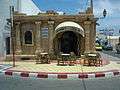 Coffeehouse.
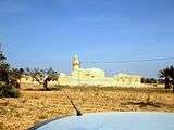 Bassi Mosque.
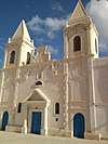 Saint Joseph Catholic Church.
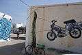 Street art in Erriadh (Djerbahood)
See also
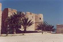
- Borj El Kebir
- Menachem Mazuz, former Israeli Attorney General, born on this island
- Yael Shelbia, Israeli model, descendant of Djerba inhabitants
- Djerba–Zarzis International Airport
References
- 1 2 3

- ↑ ^ Transliteration from http://www.uconv.com/ar.htm
- 1 2 http://whc.unesco.org/en/events/1403/
- ↑ Polybius; Strabo 1.2.17.
- 1 2 3 http://www.jpost.com/Diaspora/WATCH-Candle-lighting-in-Djerba-a-Jewish-community-to-admire-518201
- ↑ E. Fentress, A. Drine and R. Holod, eds. An Island in Time: Jerba Studies vol 1. The Punic and Roman Periods. Journal of Roman Archaeology Supplementary series 71,2009.
- ↑ Vailhé, S. (1909). "Girba". The Catholic Encyclopedia. New York: Robert Appleton Company.
- ↑ Teich, Shmuel (1982). The Rishonim. Brooklyn, New York: Mesorah Publications. ISBN 0-89906-452-3.
- 1 2 International Religious Freedom Report 2007: Tunisia. United States Bureau of Democracy, Human Rights and Labor (September 14, 2007). This article incorporates text from this source, which is in the public domain.
- ↑ http://www.languagesoftheworld.info/southwest-asia-and-north-africa/tunisias-diverse-djerba-island-and-its-annual-jewish-pilgrimage.html
- ↑ Schroeter, Daniel (1985). "Review of The Last Arab Jews: The Communities of Jerba, Tunisia, (Social Orders 1.), , , Jaques Pérez". Middle East Studies Association Bulletin. 19 (1): 63–64.
- ↑ Tunisian Cleric Says Jews are Apes - Middle East - News - Israel National News
- ↑ Spector, Shmuel; Wigoder, Geoffrey (2001). The Encyclopedia of Jewish Life Before and During the Holocaust: A-J. New York: NYU Press. p. 312. ISBN 978-0-8147-9376-3.
- ↑ Ettinger, Yair (2011-01-17). "Sociologist Claude Sitbon, do the Jews of Tunisia have reason to be afraid?". Haaretz. Retrieved 2012-10-04.
- ↑ https://www.wsj.com/articles/insular-jewish-community-of-djerba-tunisia-has-weathered-revolution-and-terrorism-but-can-it-survive-girls-education-1423869146
- ↑ Tunisian bomb attack trial opens, BBC
- ↑ "Tunisian Jewish school attacked as anti-government protests rage elsewhere".
- ↑ "Jerba Climate Normals 1961–1990". National Oceanic and Atmospheric Administration. Retrieved January 24, 2015.
- ↑ "Station Djerba" (in French). Météo Climat. Retrieved July 13, 2017.
- ↑ "Djerba Climate and Weather Averages, Tunisia". Weather2Travel. Retrieved 19 July 2014.
- ↑ "Djerba, Tunisia – Climate data". Weather Atlas. Retrieved 4 April 2017.
- ↑ http://www.ramsar.org/djerba-bin-el-ouedian
External links
| Wikivoyage has a travel guide for Djerba. |
| Wikimedia Commons has media related to Djerba. |
![]()