Gionges
| Gionges | |
|---|---|
 Gionges Location within Grand Est region  Gionges | |
| Coordinates: 48°56′10″N 3°58′51″E / 48.9361°N 3.9808°ECoordinates: 48°56′10″N 3°58′51″E / 48.9361°N 3.9808°E | |
| Country | France |
| Region | Grand Est |
| Department | Marne |
| Arrondissement | Épernay |
| Canton | Vertus-Plaine Champenoise |
| Area1 | 10.75 km2 (4.15 sq mi) |
| Population (2006)2 | 148 |
| • Density | 14/km2 (36/sq mi) |
| Time zone | UTC+1 (CET) |
| • Summer (DST) | UTC+2 (CEST) |
| INSEE/Postal code | 51271 /51130 |
|
1 French Land Register data, which excludes lakes, ponds, glaciers > 1 km2 (0.386 sq mi or 247 acres) and river estuaries. 2 Population without double counting: residents of multiple communes (e.g., students and military personnel) only counted once. | |
Gionges is a former commune in the Marne department in north-eastern France. On 1 January 2018, it was merged into the new commune of Blancs-Coteaux.[1]
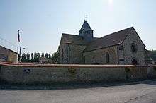
Church
See also
References
- ↑ Arrêté préfectoral 21 December 2017 (in French)
| Wikimedia Commons has media related to Gionges. |
This article is issued from
Wikipedia.
The text is licensed under Creative Commons - Attribution - Sharealike.
Additional terms may apply for the media files.