Gimsøya
 Gimsøya Location in Nordland | |
| Geography | |
|---|---|
| Location | Nordland, Norway |
| Coordinates | 68°17′30″N 14°11′11″E / 68.2918°N 14.1865°ECoordinates: 68°17′30″N 14°11′11″E / 68.2918°N 14.1865°E |
| Archipelago | Lofoten |
| Area | 46.4 km2 (17.9 sq mi) |
| Length | 11 km (6.8 mi) |
| Width | 5 km (3.1 mi) |
| Highest elevation | 767 m (2,516 ft) |
| Highest point | Bardstrandfjellet |
| Administration | |
| County | Nordland |
| Municipality | Vågan |
| Demographics | |
| Population | 207 (2001) |
Gimsøya is an island in Vågan municipality in Nordland county, Norway. Gimsøya is situated between the islands of Austvågøya and Vestvågøya in the Lofoten archipelago. The 46.4-square-kilometre (17.9 sq mi) island has a population (2001) of 207.[1]
The European route E10 highway passes through Gimsøya linking the island to Austvågøya by the Gimsøystraumen Bridge and to the island of Vestvågøya by the Sundklakkstraumen Bridge. The main population centres on Gimsøya include Vinje (where Gimsøy Elementary school is located), Hov (where the golf course is located), Hovsund (where the marina and the abandoned fish factory is located), Barstrand (where some fishing industry is located), Gimsøysand (where Gimsøy Church is located), and Årrstranda.
Geography
The southern and eastern part of Gimsøya is mountainous. The highest point is the 767-metre (2,516 ft) tall Bardstrandfjellet. In the north and west, the island is flat and marshy, with the exception of the 368-metre (1,207 ft) tall Hoven mountain. There are large protected areas in Gimsøya related to fauna and bird life. "Gimsøy marshes nature reserve" (Gimsøymyrene naturreservat) is located on the island.
Media gallery
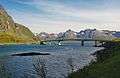 Sundklakkstraumen Bridge
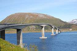 Gimsoystraumen Bridge
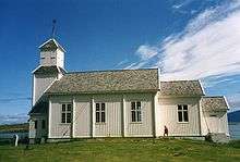 Gimsøy Church at Gimsøysand
 Abandoned house in Gimsøysand
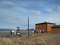 Shop and gas station on Gimsoya
References
- ↑ Store norske leksikon. "Gimsøya" (in Norwegian). Retrieved 2012-07-11.