Gibisonville, Ohio
| Gibisonville, Ohio | |
|---|---|
| Unincorporated community | |
 Gibisonville  Gibisonville | |
| Coordinates: 39°29′59″N 82°34′00″W / 39.49972°N 82.56667°WCoordinates: 39°29′59″N 82°34′00″W / 39.49972°N 82.56667°W | |
| Country | United States |
| State | Ohio |
| County | Hocking |
| Township | Laurel |
| Elevation | 1,102 ft (336 m) |
| Time zone | UTC-5 (Eastern (EST)) |
| • Summer (DST) | UTC-4 (EDT) |
| Area code(s) | 740 |
| GNIS feature ID | 1075914[1] |
Gibisonville is an unincorporated community in Hocking County, Ohio, United States. Gibsonville is located on Ohio State Route 678, 9 miles (14 km) west-southwest of Logan.
History
Gibisonville was laid out in 1840.[2] The community was named for its founders, Samuel and William Gibison.[3] A post office was established at Gibisonville in 1850, and remained in operation until 1969.[4]
References
- ↑ U.S. Geological Survey Geographic Names Information System: Gibisonville, Ohio
- ↑ History of Hocking Valley, Ohio. Inter-State Publishing Co. 1883. p. 1133.
- ↑ Maniskas, Judith S. (2011). Logan and Hocking County. Arcadia Publishing. p. 25. ISBN 9780738582894.
- ↑ "Hocking County". Jim Forte Postal History. Archived from the original on 11 December 2015. Retrieved 10 December 2015.
Municipalities and communities of Hocking County, Ohio, United States | ||
|---|---|---|
| City | 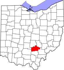 | |
| Villages | ||
| Townships | ||
| CDPs | ||
| Unincorporated communities | ||
| Footnotes | ‡This populated place also has portions in an adjacent county or counties | |
This article is issued from
Wikipedia.
The text is licensed under Creative Commons - Attribution - Sharealike.
Additional terms may apply for the media files.