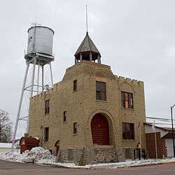
Gibbon, Minnesota
| Gibbon, Minnesota | |
|---|---|
| City | |
 | |
 Location of Gibbon within Sibley County, Minnesota | |
| Coordinates: 44°32′0″N 94°31′27″W / 44.53333°N 94.52417°W | |
| Country | United States |
| State | Minnesota |
| County | Sibley |
| Government | |
| • Type | Mayor – Council |
| • Mayor | Jeff Gatton |
| Area[2] | |
| • Total | 0.88 sq mi (2.28 km2) |
| • Land | 0.88 sq mi (2.28 km2) |
| • Water | 0 sq mi (0 km2) |
| Elevation | 1,050 ft (320 m) |
| Population (2010)[3] | |
| • Total | 772 |
| • Estimate (2016)[4] | 747 |
| • Density | 880/sq mi (340/km2) |
| Time zone | UTC-6 (Central (CST)) |
| • Summer (DST) | UTC-5 (CDT) |
| ZIP code | 55335 |
| Area code(s) | 507 |
| FIPS code | 27-23678[5] |
| GNIS feature ID | 0644116[6] |
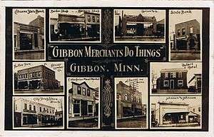
Gibbon is a city in Sibley County, Minnesota, United States. The population was 772 at the 2010 census.[7]
History
The city is named for General John Gibbon, a commandant at Fort Snelling from 1880 to 1882.
Geography
According to the United States Census Bureau, the city has a total area of 0.88 square miles (2.28 km2), all of it land.[2]
Gibbon is located along Minnesota State Highway 19 at its junction with Sibley County Road 2.
Demographics
| Historical population | |||
|---|---|---|---|
| Census | Pop. | %± | |
| 1890 | 282 | — | |
| 1900 | 545 | 93.3% | |
| 1910 | 533 | −2.2% | |
| 1920 | 583 | 9.4% | |
| 1930 | 612 | 5.0% | |
| 1940 | 761 | 24.3% | |
| 1950 | 830 | 9.1% | |
| 1960 | 896 | 8.0% | |
| 1970 | 877 | −2.1% | |
| 1980 | 787 | −10.3% | |
| 1990 | 712 | −9.5% | |
| 2000 | 808 | 13.5% | |
| 2010 | 772 | −4.5% | |
| Est. 2016 | 747 | [4] | −3.2% |
| U.S. Decennial Census[8] | |||
As of 2000 the median income for a household in the city was $37,321, and the median income for a family was $53,125. Males had a median income of $31,413 versus $30,694 for females. The per capita income for the city was $17,897. About 3.6% of families and 7.4% of the population were below the poverty line, including 10.7% of those under age 18 and 8.0% of those age 65 or over.
2010 census
As of the census[3] of 2010, there were 772 people, 353 households, and 210 families residing in the city. The population density was 877.3 inhabitants per square mile (338.7/km2). There were 394 housing units at an average density of 447.7 per square mile (172.9/km2). The racial makeup of the city was 95.5% White, 1.3% African American, 0.3% Asian, 2.3% from other races, and 0.6% from two or more races. Hispanic or Latino of any race were 3.4% of the population.
There were 353 households of which 26.1% had children under the age of 18 living with them, 47.6% were married couples living together, 8.5% had a female householder with no husband present, 3.4% had a male householder with no wife present, and 40.5% were non-families. 37.4% of all households were made up of individuals and 20.4% had someone living alone who was 65 years of age or older. The average household size was 2.19 and the average family size was 2.85.
The median age in the city was 44.6 years. 22.8% of residents were under the age of 18; 5.4% were between the ages of 18 and 24; 22.1% were from 25 to 44; 25.7% were from 45 to 64; and 23.8% were 65 years of age or older. The gender makeup of the city was 48.6% male and 51.4% female.
Notable people
- Doloris Bridges, New Hampshire politician
Education
Gibbon is the district office and elementary school home of GFW ISD #2365. It also hosts Prairie Lutheran School, St. Peter's Lutheran School and the Starland School.
Sports
Gibbon has a Tomahawk East League baseball team, the Gibbon Reds.
References
- 1 2 Nord, Mary Ann (2003). The National Register of Historic Places in Minnesota. Minnesota Historical Society. ISBN 0-87351-448-3.
- 1 2 "US Gazetteer files 2010". United States Census Bureau. Archived from the original on 2011-07-21. Retrieved 2012-11-13.
- 1 2 "American FactFinder". United States Census Bureau. Retrieved 2012-11-13.
- 1 2 "Population and Housing Unit Estimates". Retrieved June 9, 2017.
- ↑ "American FactFinder". United States Census Bureau. Archived from the original on 2013-06-17. Retrieved 2008-01-31.
- ↑ "US Board on Geographic Names". United States Geological Survey. 2007-10-25. Retrieved 2008-01-31.
- ↑ "2010 Census Redistricting Data (Public Law 94-171) Summary File". American FactFinder. United States Census Bureau. Archived from the original on 21 July 2011. Retrieved 27 April 2011.
- ↑ "Census of Population and Housing". Census.gov. Archived from the original on June 2, 2016. Retrieved June 4, 2015.
External links
Municipalities and communities of Sibley County, Minnesota, United States | ||
|---|---|---|
| Cities | 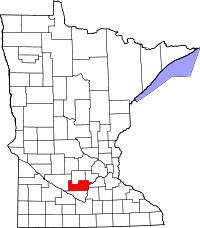 | |
| Townships | ||
| Unincorporated communities | ||
| Footnotes | ‡This populated place also has portions in an adjacent county or counties | |
Coordinates: 44°32′02″N 94°31′35″W / 44.53389°N 94.52639°W