Gettysburg National Military Park
| Gettysburg National Military Park Gettysburg National Park (1893) Gettysburg Park | |
|---|---|
|
IUCN category III (natural monument or feature) | |
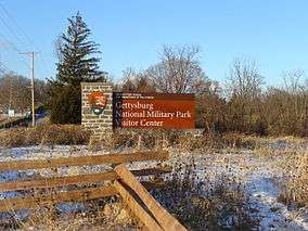 The 2008 sign for the PA 134 (west) Visitor Center entrance is a National Park Service rustic structure built to appear as if the base wall and column are of Gettysburg Granite, a locally-quarried material in structures during the Battle of Gettysburg. | |
| Nearest city | Gettysburg, Pennsylvania |
| Coordinates | 39°48′31″N 77°14′12″W / 39.80861°N 77.23667°WCoordinates: 39°48′31″N 77°14′12″W / 39.80861°N 77.23667°W |
| Area |
3,965 acres (16.05 km2) (as of 2009)[1] 1963: 2,871 acres 1932: 2,530 acres 1916: ~2,302 acres[2] 1900: 1,221 acres 1888: 540 acres |
| Established |
1966: added to NRHP (#66000642)[3] 1895: national park designation 1893: federal protection 1864: GBMA protection 1863: initial protection |
| Visitors | 1,031,554 (in 2010) |
| Governing body |
1933: National Park Service 1896: War Department 1864: Gettysburg Battlefield Memorial Association |
| Website | Gettysburg National Military Park |
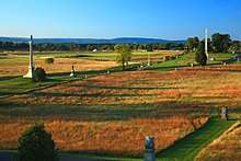
The Gettysburg National Military Park protects and interprets the landscape of the 1863 Battle of Gettysburg during the American Civil War. Located in Gettysburg, Pennsylvania, the park is managed by the National Park Service.[4] The GNMP properties include most of the Gettysburg Battlefield, many of the battle's support areas during the battle (e.g., reserve, supply, & hospital locations), and several other non-battle areas associated with the battle's "aftermath and commemoration", including the Gettysburg National Cemetery.[5] Many of the park's 43,000 American Civil War artifacts are displayed in the Gettysburg Museum and Visitor Center.[6]
The park has more wooded land than in 1863, and the National Park Service has an ongoing program to restore portions of the battlefield to their historical non-wooded conditions, as well as to replant historic orchards and woodlots that are now missing. In addition, the NPS is restoring native plants to meadows and edges of roads, to encourage habitat as well as provide for historic landscape. There are also considerably more roads and facilities for the benefit of tourists visiting the battlefield park.
In 1915, the "National Park Commission" tested the battlefield guides and, due to the limited knowledge (particularly of the most experienced, e.g., only 1 in 8 could name the 7 avenues), established a school for licensing tour guides to charge fees.[7]
Federal land acquisition
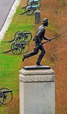
The 1864 Gettysburg Battlefield Memorial Association and later veteran's associations acquired land for memorials and preservation (e.g., the 72nd Pennsylvania Infantry Monument tract with the statuary memorial depicted on the 2011 America the Beautiful Quarter dollar). Federal acquisition of land that would become the 1895 national park began on June 7, 1893, with 9 monument tracts of 625 sq ft (58.1 m2) each and a larger 10th lot of 1.2 acres (4,900 m2) from the Association, as well as 0.275 acres (1,110 m2) from Samuel M Bushman.[2] In addition to land purchases, federal eminent domain takings include the Gettysburg Electric Railway right-of-ways in 1917 (cf. 1896 United States v. Gettysburg Electric Ry. Co.). Donated land included 160 acres from the 1959 Gettysburg Battlefield Preservation Association and 264 acres (107 ha) from the W. Alton Jones Foundation.[8]:42 The Gettysburg Foundation is a 501(c)(3) non-profit philanthropic, educational organization that operates in partnership with the National Park Service to preserve Gettysburg National Military Park and the Eisenhower National Historic Site, and to educate the public about their significance.[9] (e.g., the Foundation raised funds for and built the new Museum and Visitor Center, opened in 2008, and secured funds for the creation of a new cannon shop that daily preserves the nearly 400 cannons representing actual artillery lines on the battlefield. In addition, the Gettysburg Foundation has provided approximately $20 million in direct support of the National Park Service just since 2009. The Visitor Center houses the Gettysburg Museum of the American Civil War and the 19th century, painting in the round, the Gettysburg Cyclorama)[10]
In February 2009, The David Wills House where Lincoln completed his Gettysburg Address was added to the national park by Public Law 106-290 and is operated by Gettysburg Foundation.[11] In 2010, an effort to expand the amount of the federally-owned GNMP land failed in Congress.[12]
Memorials and remembrance
The Park has been a highly symbolic venue for memorials and remembrance. On November 19, 1963 a parade and ceremony was held in Gettysburg commemorating the centennial of President Lincoln's Gettysburg Address, given less than five months after the Battle of Gettysburg. The actor, Raymond H. Massey, playing the role of President Lincoln arrived by 1860's period steam train at the Gettysburg station. He rode, in the parade as did Lincoln, on horseback to the National cemetery where actor Massey gave the President's famous address (this time for brevity, Edward Everett's preceding two hour speech was not read). The parade followed the same route that President Lincoln and Gov. Andrew G. Curtin took 100 years before. Former President Dwight D. Eisenhower—who lived nearby—was there accompanied by Gov. William W. Scranton. The attendance at the 1963 commemoration was lower than the 20,000 to 30,000 persons who attended the original address by President Lincoln in 1863. Thousands of photographers attended the 1963 event while U.S. Air Force aircraft passed overhead. Also attending the event were the 28th Division of the Pennsylvania National Guard headed by Maj. Gen. Henry F. Fluck, the U.S. Marine Band, and the 3rd Infantry Regiment (The Old Guard) of the U.S. Army. The parade ended at the rear entrance into the Gettysburg National Cemetery.[13]
References
- ↑ Cultural Landcapes Inventory: Professional Procedures Guide (PDF) (Report). NPS.gov. January 2009. Retrieved 2011-02-22.
The approximately 11,000-acre Gettysburg Battlefield Historic District embraces the land area associated with the battle of Gettysburg. ... In a more complex park, such as Gettysburg National Military Park, the CLI could identify the 3,965 acre park as the landscape
- 1 2 "Gettysburg National Park". United States military reservations, National cemeteries, and military parks. 1916. Retrieved 2011-03-11.
- ↑ "Adams County - Historic Districts". NationalRegisterOfHistoricPlaces.com. Retrieved 2011-02-13.
- ↑ E011715 (undated document--June 29, 2009 embedded in file). "The New Visitor Experience at Gettysburg National Military Park, Facts at a Glance" (PDF). NPS.gov. Retrieved 2011-03-11. Check date values in:
|date=(help) - ↑ National Register Nomination, January 23, 2004 [March 19, 1975], archived from the original on July 21, 2011, retrieved 2011-02-19
- ↑ https://news.google.com/newspapers?id=jiNaAAAAIBAJ&sjid=4EsNAAAAIBAJ&pg=1331,4924500&dq=civil-war-preservation-trust+gettysburg&hl=en
- ↑ "To Have School For The Guides". September 20, 1915. Retrieved 2011-02-18.
- ↑ Davis, William C. (1995--Fifth Printing) [1983]. Gettysburg: The Story Behind the Scenery. pp. 17, 42. ISBN 0-916122-89-1. LCCN 83-80606. Check date values in:
|year=(help) - ↑ "Gettysburg Foundation". FriendsOfGettysburg.org. Retrieved 2011-02-08.
In 2006, [the Gettysburg National Battlefield Museum Foundation] merged with the [1989] Friends of the National Parks at Gettysburg, forming the Gettysburg Foundation.
- ↑ "Preservation". Gettysburg Foundation. GettysburgFoundation.org. Retrieved 2017-12-21.
- ↑ Senate Report 111-330 - BOUNDARY REVISION OF THE GETTYSBURG NATIONAL MILITARY PARK. Gpo.gov. Retrieved on 2013-07-23.
- ↑ Kanagy, Beth (March 2, 2001). "Preservation and progress a delicate balancing act along 'endangered' Pike". Retrieved 2011-02-19.
Historic easements are very stringent, … they only occur inside the Park boundary. … In essence a conservation easement preserves a residential property … but limit changes to the exterior of properties.
- NOTE: As opposed to the actual ownership boundary of federal land administered by the Gettysburg National Military Park (GNMP), the quoted "Park boundary" refers to the land acquisition limits imposed by Congress on the Secretary of the Interior. Initially 3,874 acres in 1895, the limits were expanded in 1990 but a 2010 bill by Representative Platt failed in the US Senate regarding expanding them to allow acquisition of the Gettysburg Railroad Station and the 45-acre (18 ha) Wayne and Susan Hill tract south of Big Round Top.
- ↑ The Gettysburg Times (Wednesday, November 20, 1963), Procession To Cemetery Was Similar To '63 Event, pp. 1, 10
External links
| Wikimedia Commons has media related to Gettysburg National Military Park. |
- Official website
- "Writings of Abraham Lincoln", broadcast from Gettysburg National Military Park from C-SPAN's American Writers
- Historic American Engineering Record (HAER) No. PA-485, "Gettysburg National Military Park Tour Roads"
All of the following are filed under Gettysburg, Adams County, Pennsylvania:
- HABS No. PA-1964, "Theodore Bender House, East of Herr's Ridge Road, West of Buford Avenue"
- HABS No. PA-5940-A, "Biggs Farm, House"
- HABS No. PA-1963, "Blocher House, Tablerock Road, off Route 34"
- HABS No. PA-355, "Bricker Outdoor Bake Oven, Taneytown & Wheat Fields Roads"
- HABS No. PA-342, "Bryan House, Hancock Avenue"
- HABS No. PA-365, "Bushman House"
- HABS No. PA-365-A, "Bushman Barn, Business U.S. 15, Emmitsburg Road"
- HABS No. PA-1965, "Cobean Farm, State Route 34 North"
- HABS No. PA-354, "Culp Farm House"
- HABS No. PA-5379, "Culp Farm & Smokehouse, West of Rock Creek"
- HABS No. PA-5379-A, "Culp Farm, Barn"
- HABS No. PA-5379-B, "Culp Farm, Springhouse"
- HABS No. PA-5379-C, "Culp Farm, Woodshed"
- HABS No. PA-1961, "Hummelbaugh Farm, Pleasonton Avenue"
- HABS No. PA-1961-A, "Hummelbaugh Farm, House"
- HABS No. PA-5939-A, "Klingel Farm, House"
- HABS No. PA-341, "Lydia Leister House, Taneytown Road & Meade Avenue"
- HABS No. PA-341-A, "Lydia Leister Barn, Taneytown Road (State Route 134) & Hunt Avenue"
- HABS No. PA-1187, "McClean House, Mummasburg Road (Cumberland Township)"
- HABS No. PA-580, "William Patterson House, Taneytown Road (Route 134), Pleasonton Avenue vicinity"
- HABS No. PA-5348, "Rose Barn, Emmitsburg Road (U.S. Route 15)"
- HABS No. PA-356, "Slyder House, Plum Run near Big Round Top"
- HABS No. PA-356-A, "Slyder House, Kitchen"
- HABS No. PA-356-B, "Slyder Barn"
- HABS No. PA-357, "Spangler Farm Carriage House, Emmitsburg Road (U.S. Route 15)"
- HABS No. PA-1960, "Spangler Farm, Emmitsburg Road (U.S. 15)"
- HABS No. PA-1960-A, "Henry Spangler Farm, House"
- HABS No. PA-1960-B, "Spangler Farm, Summer Kitchen"
- HABS No. PA-1960-C, "Spangler Farm, Storage House & Woodshed"
- HABS No. PA-1962, "Trostle Barn, Emmitsburg Road (U.S. 15)"
- HABS No. PA-358, "Weikert Barn, Emmitsburg Road, U.S. 15"
- HABS No. PA-363, "Weikert House, (Cumberland Township)"
- HABS No. PA-353, "Weikert Summer Kitchen, (Cumberland Township)"