Georgia State Route 187
| ||||
|---|---|---|---|---|
 | ||||
| Route information | ||||
| Maintained by GDOT | ||||
| Length | 27.0 mi[1] (43.5 km) | |||
| Major junctions | ||||
| West end |
| |||
| East end |
| |||
| Location | ||||
| Counties | Clinch, Echols | |||
| Highway system | ||||
| ||||

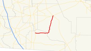
State Route 187 (SR 187) is a 27.0-mile-long (43.5 km) state highway in the south-central part of the U.S. state of Georgia. It connects Mayday to Homerville.
Route description
SR 187 begins in Echols County in Mayday at an intersection with US 129/SR 11. This is the only major junction in the county.[2] The road enters Clinch County southwest of Homerville. In town, SR 187 meets its eastern terminus, an intersection with US 441/SR 89.[3]
Major intersections
| County | Location | mi[1] | km | Destinations | Notes |
|---|---|---|---|---|---|
| Echols | Mayday | 0.0 | 0.0 | Western terminus | |
| Clinch | Homerville | 27.0 | 43.5 | Eastern terminus | |
| 1.000 mi = 1.609 km; 1.000 km = 0.621 mi | |||||
See also
.svg.png)

References
- 1 2 Google (December 15, 2013). "Route of SR 187" (Map). Google Maps. Google. Retrieved December 15, 2013.
- ↑ Functional Classification Map: Echols County, Georgia (PDF) (Map). Cartography by Office of Transportation Data. Georgia Department of Transportation. July 2010. Retrieved December 11, 2011.
- ↑ Functional Classification Map: Clinch County, Georgia (PDF) (Map). Cartography by Office of Transportation Data. Georgia Department of Transportation. October 2010. Retrieved December 11, 2011.
This article is issued from
Wikipedia.
The text is licensed under Creative Commons - Attribution - Sharealike.
Additional terms may apply for the media files.