Geography of Salt Lake City
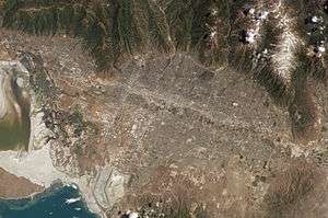
Salt Lake City is located in a large valley, the Salt Lake Valley, separated by the Wasatch Mountains to the east and the Oquirrh Mountains to the west. Salt Lake City is located at 40°45'17" North, 111°53'33" West (40.754700, -111.892622).[1]
According to the United States Census Bureau, the city has a total area of 285.9 km² (110.4 mi²). 282.5 km² (109.1 mi²) of it is land and 3.3 km² (1.3 mi²) of it is water. The total area is 1.17% water.
Like most of the cities stretching north and south of Salt Lake City (see Ogden and Provo), it lies at the base of the Wasatch Mountains, which in some places rise impressively 6,000 feet (1,850 m) above the valley floor. This metro area is known commonly as the Wasatch Front. Most of the valley floor is built up, except for some rapidly disappearing fields and farms on the south and west sides of the valley. Some parts of the benches have residential construction. The valley floor is the lake bed of the ancient Lake Bonneville, of which the Great Salt Lake is a remnant. Soils in the valley are largely clay and sand, which exposes the city's edifices to considerable risk of damage due to liquefaction caused by an earthquake. The Wasatch Fault runs along the eastern benches of the city, and geologists consider it due for a major earthquake. On February 21, 2008 an earthquake hit northern Utah, including Salt Lake City.[2]
The marshlands and mudflats to the south and east of the Great Salt Lake border the city's northwest side. Freshwater estuaries enter the lake here, and the lower salinity combines with the marshy terrain to result in considerable algae growth. Under certain weather conditions, which occur up to roughly a dozen times a year, some of the algae dies off and decays, and the northwest winds carry the scent of decaying algae into the city. The smell is known as "lake stink".
References
- ↑ "US Gazetteer files: 2010, 2000, and 1990". United States Census Bureau. 2011-02-12. Retrieved 2011-04-23.
- ↑ Mims, Bob (2008-02-21). "Quake shakes northern Utah; downtown SLC buildings sway". The Salt Lake Tribune. Retrieved 2008-02-21.
Coordinates: 40°45′17″N 111°53′33″W / 40.75472°N 111.89250°W