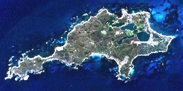
Geography of Rottnest Island
Rottnest Island lies 18 kilometres west of the coastline of Perth, Western Australia, and is 4.5 km (2.8m) at its widest, and 11 km long.
Coastline features
The coastline is approximately 24 kilometres long, and the bays, points, reefs and smaller islands are extensively named.
Topography
The named hills of Rottnest are Oliver Hill, Radar Hill and Mount Herschel, and the main lighthouse of the island is known as Wadjemup Lighthouse.
Named coastal features
- Abraham Point
- Armstrong Rock
- Army Jetty
- Basin (usually known as The Basin)[1]
- Bathurst Point – location of the Bathurst Lighthouse
- Bickley Bay – just south of Kingstown Barracks
- Bickley Point
- Cape Vlamingh – also known as West End
- Cathedral Rocks – north west of West End
- Catherine Bay
- City of York Bay – west of Little Armstrong Bay
- Crayfish Rocks
- Duck Rock
- Dyer Island
- Eagle Bay – at the West End
- Fairbridge Bluff
- Fay's Bay
- Fish Hook Bay
- Green Island
- Henrietta Rocks
- Kingstown
- Little Armstrong Bay
- Little Parakeet Bay
- Little Salmon Bay
- Longreach Bay – between the Basin and Geordie Bay
- Mabel Cove
- Marjorie Bay
- Mary Cove
- Mushroom Rock
- Nancy Cove – narrowest part of Island
- Narrow Neck
- North Point
- Parakeet Bay
- Parker Point – southernmost point
- Phillip Point
- Phillip Rocks
- Pinky Beach
- Porpoise Bay
- Radar Reef – at West End
- Ricey Beach
- Rocky Bay
- Salmon Bay
- Salmon Point
- South Point
- Stark Bay
- Strickland Bay[2]
- Thomson Bay
- Vera Rocks
- Wallace Island
- West End
- Wilson Bay
Named lakes
- Garden Lake
- Geordie Bay
- Government House Lake[3]
- Lake Baghdad
- Lake Herschel/ Herschel Lake
- Lake Negri
- Lake Sirius
- Lake Timperley
- Lake Vincent
- Pearse Lake
- Serpentine Lake
Wells and bores
The island is very limited in water supply and considerable numbers of bores have been sunk to keep water supply available.[4]
In 1976, Philip Playford's Geological Map of Rottnest[5] identified wells, abandoned wells, and bores on the island. The following is only a select list of the full range.
West end
- Radar Hill just east of Cape Vlaming had Radar Station Well and was designated "abandoned".
South coast
- Parker Point between Salmon Bay And Porpoise Bay, had Parker Point Bores as "abandoned", closer to Tree Hill the well and bore were active.
See also
- Rottnest Island shipwrecks — details on the twelve larger shipwrecks in close proximity to the island
- Colonial buildings of Rottnest Island
- Islands of Perth, Western Australia
Notes
- ↑ Orloff, Izzy; HRRC (1922), The Basin, Rottnest, retrieved 17 December 2011
- ↑ Known as 'Narrow Neck Bay' changed to Strickland in 1913 "Rottnest Island". The West Australian. Perth: National Library of Australia. 21 May 1913. p. 9. Retrieved 14 April 2013.
- ↑ "YACHTING". The West Australian (Perth, WA : 1879 - 1954). Perth, WA: National Library of Australia. 5 April 1926. p. 10. Retrieved 11 December 2015.
- ↑ Smith, RA (1994), "Groundwater Exploitation and Management on a Small Semiarid Island", Water Down Under 94: Groundwater/Surface Hydrology Common Interest Papers; Preprints of Papers, Institution of Engineers, Australia: 473–478, ISBN 978-0-85825-607-1
- ↑ Playford, Phillip E. (Phillip Elliott); Leech, R. E. J; Geological Survey of Western Australia (1976), Geological map of Rottnest Island, Geological Survey of Western Australia, ISBN 978-0-7244-6399-2 see also later edition in 1992 Playford, Phillip E. (Phillip Elliott); Leech, R. E. J; Geological Survey of Western Australia (1992), Geological map of Rottnest Island, Geological Survey of Western Australia, retrieved 11 December 2015
External links
| Wikimedia Commons has media related to Rottnest Island. |
This article is issued from
Wikipedia.
The text is licensed under Creative Commons - Attribution - Sharealike.
Additional terms may apply for the media files.