ECEF
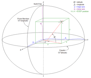
ECEF (acronym for earth-centered, earth-fixed), also known as ECR (initialism for earth-centered rotational), is a geographic and Cartesian coordinate system and is sometimes known as a "conventional terrestrial" system.[1] It represents positions as X, Y, and Z coordinates. The point (0, 0, 0) is defined as the center of mass of Earth,[2] hence the term geocentric coordinates.
Its axes are aligned with the international reference pole (IRP) and international reference meridian (IRM) that are fixed with respect to Earth's surface,[3][4] hence the descriptor earth-fixed. This term can cause confusion, since Earth does not rotate about the z-axis (unlike an inertial system such as ECI), and is therefore alternatively called ECR.
The z-axis extends through true north, which does not coincide with the instantaneous Earth rotational axis.[3] The slight "wobbling" of the rotational axis is known as polar motion.[5] The x-axis intersects the sphere of the earth at 0° latitude (the equator) and 0° longitude (prime meridian in Greenwich). This means that ECEF rotates with the earth, and therefore coordinates of a point fixed on the surface of the earth do not change. Conversion from a WGS84 datum to ECEF can be used as an intermediate step in converting velocities to the north east down coordinate system.
Conversions between ECEF and geodetic coordinates (latitude and longitude) are discussed at geographic coordinate conversion.
In astronomy
Geocentric coordinates can be used for locating astronomical objects in the Solar System in three dimensions along the Cartesian X, Y, and Z axes. They are differentiated from topocentric coordinates, which use the observer's location as the reference point for bearings in altitude and azimuth. However, neither system takes Earth's constant motion into account, which requires the addition of a time component to fix objects.
For nearby stars, astronomers use heliocentric coordinates, with the center of the Sun as the origin. The plane of reference can be aligned with the Earth's celestial equator, the ecliptic, or the Milky Way's galactic equator. These 3D celestial coordinate systems add actual distance as the Z axis to the equatorial, ecliptic, and galactic coordinate systems used in spherical astronomy.
The distances involved are so great compared to the relative velocities of the stars, that for most purposes, the time component can be neglected.
See also
- Geodetic system
- Earth-centered inertial coordinate system
- International Terrestrial Reference System (ITRS)
- Orbital state vectors
References
- ↑ Leick, Alfred (2004). GPS Satellite Surveying. Wiley.
- ↑ Clynch, James R. (February 2006). "Earth Coordinates" (PDF). Archived from the original (PDF) on 2015-04-18.
- 1 2 "Archived copy" (PDF). Archived from the original (PDF) on 2011-07-18. Retrieved 2010-12-07.
- ↑ "Archived copy". Archived from the original on 2011-07-18. Retrieved 2010-12-07.
- ↑ "Archived copy". Archived from the original on 2011-06-13. Retrieved 2010-12-07.
External links
- ECEF datum transformation Notes on converting ECEF coordinates to WGS-84 datum
- Datum Transformations of GPS Positions Application Note Clearer notes on converting ECEF coordinates to WGS-84 datum
- geodetic datum overview orientation of the coordinate system and additional information
- GeographicLib includes a utility CartConvert which converts between geodetic and geocentric (ECEF) or local Cartesian (ENU) coordinates. This provides accurate results for all inputs including points close to the center of the earth.
- EPSG:4978