Gennargentu
| Gennargentu | |
|---|---|
|
Ghennarghentu | |
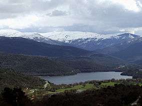 View of Gennargentu and Gusana Lake in spring | |
| Highest point | |
| Peak | Punta La Marmora |
| Elevation | 1,834 m (6,017 ft) |
| Geography | |
 | |
| Country | Italy |
| State/Province | Sardinia |
| Range coordinates | 40°01′N 9°19′E / 40.017°N 9.317°ECoordinates: 40°01′N 9°19′E / 40.017°N 9.317°E |
Gennargentu (Italian: [dʒennarˈdʒɛntu]; Sardinian: Ghennarghentu [ɡennaɾˈɡentu]) is a large massif in central-southern Sardinia, Italy, encompassing the provinces of Nuoro and Ogliastra. It includes the highest peaks on the island, such as Punta La Marmora (1,834 m or 6,017 ft), Monte Spada (1,595 m or 5,233 ft), Punta Erba Irdes (1,676 m or 5,499 ft), Bruncu Spina (1,829 m or 6,001 ft) and Punta Paulinu (1,792 m or 5,879 ft).
The range forms part of the Gennargentu National Park. Geologically, its rocks are amongst the oldest in Europe, and are therefore smooth shaped: rock types include schist, limestone and granite.
Toponymy
The etymology of the name Gennargentu is not attested: it could mean "Silver Door" (Sardinian: jenna (d)e arghentu), "Door of the Winds" (jenna de bentu) or "Door of Absinthium" (jenna de assentu).
Ski resorts
The mountains are home to the only ski resorts on the island: on Monte Spada, Bruncu Spina, Separadorgiu and S'Arena.[1][2]