Gebo, Wyoming
| Gebo, Wyoming | |
|---|---|
| Unincorporated community | |
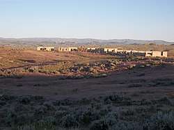 Gebo in the evening | |
 Gebo  Gebo | |
| Coordinates: 43°47′27″N 108°13′49″W / 43.79083°N 108.23028°WCoordinates: 43°47′27″N 108°13′49″W / 43.79083°N 108.23028°W | |
| Country | United States |
| State | Wyoming |
| County | Hot Springs |
| Elevation | 4,491 ft (1,369 m) |
| Time zone | UTC-7 (Mountain (MST)) |
| • Summer (DST) | UTC-6 (MDT) |
| Area code(s) | 307 |
| GNIS feature ID | 1588848[1] |
Gebo is a ghost town located in Hot Springs County in the U.S. state of Wyoming. It is located about 12 miles (19 km) north of Thermopolis.
The town was established as a coal town in 1907 alongside the nearby camps of Crosby and Kirby.[2] It was named after Samuel Wilford Gebo who established the Owl Creek Coal Company and the first mine in the area after immigrating to America from Canada. Mining remained active until 1938. At its height, over 20,000 people lived in the area, mostly miners and their families, making Gebo briefly the largest town in the county.[2]
The remains of the town were bulldozed in 1971, though some buildings and the cemetery remain.[3]
References
- ↑ "Gebo". Geographic Names Information System. United States Geological Survey.
- 1 2 "Coal Camps, Gebo". Wyoming Tales and Trails.
- ↑ "Gebo Cemetery". washakiecounty.com.
Municipalities and communities of Hot Springs County, Wyoming, United States | ||
|---|---|---|
| Towns | 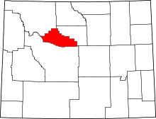 | |
| CDPs | ||
| Unincorporated community | ||
| Ghost town | ||
| Indian reservation | ||
This article is issued from
Wikipedia.
The text is licensed under Creative Commons - Attribution - Sharealike.
Additional terms may apply for the media files.