Gaviota Peak
| Gaviota Peak | |
|---|---|
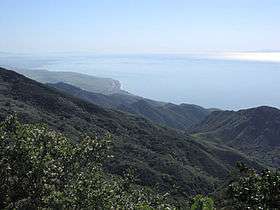 View from Gaviota Peak, looking southeast | |
| Highest point | |
| Elevation | 2,460 ft (750 m) NAVD 88[1] |
| Prominence | 198 ft (60 m) [2] |
| Coordinates | 34°30′06″N 120°11′56″W / 34.501804528°N 120.198780133°WCoordinates: 34°30′06″N 120°11′56″W / 34.501804528°N 120.198780133°W [1] |
| Naming | |
| Translation | Seagull Peak (Spanish) |
| Geography | |
 Gaviota Peak | |
| Parent range | Santa Ynez Mountains |
| Topo map | USGS Solvang |
| Climbing | |
| Easiest route | Hike |
Gaviota Peak is a summit in the Santa Ynez Mountains in Santa Barbara County, California. It is located 10 miles (16 km) west of Santa Barbara, 16 miles (26 km) east of Point Conception and 2 miles (3.2 km) from the Pacific Ocean.
The Gaviota Peak Fire Road trail starts near the junction of U.S. Route 101 and California State Route 1, in Gaviota State Park, and ends on the summit in the Los Padres National Forest. The trail passes Gaviota Hot Springs, and offers views of the Santa Ynez Mountains, Lompoc Valley, the Pacific Ocean and the Channel Islands.[3]
Gaviota Grade, is the most formidable in length and elevation change along U.S. Route 101 in Southern California.
See also
References
- 1 2 "Gaviota". NGS data sheet. U.S. National Geodetic Survey. Retrieved 2009-08-03.
- ↑ "Gaviota Peak, California". Peakbagger.com. Retrieved 2009-08-03.
- ↑ "Gaviota State Park Brochure" (PDF). California Department of Parks and Recreation. Retrieved 2011-05-31.
External links
- "The Great Lower Peaks List as of 2010". Angeles Chapter, Sierra Club. Archived from the original on 2012-06-10. Retrieved 2011-05-31.
This article is issued from
Wikipedia.
The text is licensed under Creative Commons - Attribution - Sharealike.
Additional terms may apply for the media files.