Garysville, Virginia
| Garysville | |
|---|---|
| Unincorporated community | |
 Garysville Location within the Commonwealth of Virginia  Garysville Garysville (the US) | |
| Coordinates: 37°15′00″N 77°09′28″W / 37.25000°N 77.15778°WCoordinates: 37°15′00″N 77°09′28″W / 37.25000°N 77.15778°W | |
| Country | United States |
| State | Virginia |
| County | Prince George |
| Elevation | 43 ft (13 m) |
| Time zone | UTC−5 (Eastern (EST)) |
| • Summer (DST) | UTC−4 (EDT) |
| GNIS feature ID | 1477341[1] |
Garysville is an unincorporated community in Prince George County, Virginia, United States. It is located on State Route 10 about 12 miles east of Petersburg.
The Flowerdew Hundred Plantation, listed on the National Register of Historic Places, is located in Garysville.
External links
References
Municipalities and communities of Prince George County, Virginia, United States | ||
|---|---|---|
| CDPs | 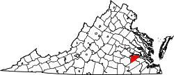 | |
| Unincorporated communities | ||
This article is issued from
Wikipedia.
The text is licensed under Creative Commons - Attribution - Sharealike.
Additional terms may apply for the media files.