Garur
| Garur Katuyr Ghati | |
|---|---|
| Town | |
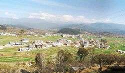 Garur Skyline | |
| Nickname(s): Katuyr Ghati | |
 Garur Location in Uttarakhand, India  Garur Garur (India) | |
| Coordinates: 29°53′52″N 79°37′00″E / 29.89788°N 79.616798°ECoordinates: 29°53′52″N 79°37′00″E / 29.89788°N 79.616798°E | |
| Country |
|
| State | Uttarakhand |
| District | Bageshwar |
| Named for | Temple of garur, a holy hindu bird |
| Elevation | 1,150 m (3,770 ft) |
| Population (January 2014) | |
| • Total | Approx 15,000 |
| • Density | 2,500/km2 (6,000/sq mi) |
| Languages | |
| • Official | Hindi |
| Time zone | UTC+5:30 (IST) |
| PIN | 263641 |
| Vehicle registration | UK |
| Nearest city | Almora, Bageshwer, Nainital & Haldawni |
| Lok Sabha constituency | Almora Pithoragarh |
| Climate | Summer 25 degree and winter 0 to 10 (Köppen) |
| Website |
uk |
Garur is a town in the Bageshwar district of the state of Uttarakhand, India.[1]
Geography and demographics
Nearby places include Kausani, Baijnath, Kot Bhramari Gwaldam and Bageshwar.
After Kausani, Garur is midway between Gwaldam and Bageshwar and is a major bus station for KMVN buses and is close to 490 kilometres away from Delhi on route to Delhi-Gajraula-Muradabad-Bhawali-Khairna-Almora-Someshwar-Kausani-Garur-Baijnath - Gwaldam.
The neighbouring villages also include Garhsher,Matena, Gagrigol, Chitrapal, Tilsari, Salani, Mattee, Bheta, Lobanj, Dangoli, Wajula, Dhaina. Garur is about 16 km away from Kausani. From Garur about 25 km is Gwaldam which comes in Garhwal.
Some of villages nearby Garur are Silli, Amoli, Matena (Joshikhola), Darsani, Anna, Paye, Jijoli, Bhagartola, Dyonai, Motisyari, Baijnath, Shemar and Kajuli.
There is a bus service from Anand Vihar Bus Terminus in New Delhi and there are air-conditioned as well as non-air-conditioned buses travelling between Delhi to Bageshwar via Garur or Delhi to Tharali via Garur all plying in the evening. Train services i.e. Anand Vihar - Shatabdi Express Train available up to Kathgodown, Ranikhet Express as well as Sampark Kranti Express Train are available from Old Delhi Railway Station up to Kathgodown and also train services up to Kathgodowm can be used from Lucknow, Jaipur, Derhradun and Kolkata.
Heritage
Around 5–6 km from Garur there is a temple of Bhagwati Mata (Kot Ka Mandir) (traces of Ma Bhramri can be found in the last two paragraph of Chapter Eleven of Durga Shaptashati Path - The most sacred Hindu Book equivalent to Gita and Ramayana), which once was a fort owned by the Katyuri Kings. Also there is a myth that Adi Shankaracharya stayed on this temple overnight while en route to Badrinath. There is widespread belief among the local populace that the face of the goddess Kot Bhramri Devi (after whom the temple is named), should not be shown to anyone except the priest of the temple. It is said that if this advice is not followed, the entire Katur Valley will face ill luck and a massive disaster will follow. Hence only the rear side of the goddess is worshipped, except during the annual festival of "Nandaashtmi" during Bhadrapad Ashtami or Radha Ashtami during September month (the state government declares as State holiday) or when the Raj Jaat Yatra which takes place once in twelve years. In the last 150 years, buffalo and lamb used to be sacrificed in the name of Nandaashtami. However, this practice has been stopped by The Honorable High Court of Nainital on a Public Interest Litigation filed by the Animal Protection Society; it is enforced by police protection. Though the Goddess Ma Bhramri is Satvik but some 200 years back during Nepalese Invasion and their Kingdom, local deity Ma Nandadevi's status got installed at Kot Bhramri Mandir as a result animal sacrifice got started some 200 years back.
The temple of Baijnath (Lord Shiva) on the bank of the river is said to have been built by the Kumaon Katyuri king in around 1150 A.D. and it was Capital of the Katyuri dynasty of kings who ruled Uttaranchal during 12th and 13th century, Baijnath was once known as Kartikyapura. One of the most important places to visit in Baijnath is the historically and religiously significant Baijnath Temple constructed in the twelfth century. The temple holds significance because, according to Hindu mythology, Lord Shiva and Parvati were married at the confluence of River Gomati its other name in Hindu mythology known as GOMI River. (originated from Aana village path of the Kausani. known as Pinath Velly. Here, Lord Shiva huge temple called Pinath Mandir) and Garur Ganga. Dedicated to SivaVaidyanatha, the Lord of Physicians, the Baijnath temple is actually a complex of temples built by the Katyuri kings with the idols of Shiva, Ganesh, Parvati, Chandika, Kuber, Surya and Brahma. Also the town of Baijnath draws its name from the temple. Situated on the left bank of the Gomti River at an elevation of 1,126 m, the temples are constructed in stone. The main temple that houses a beautiful idol of Parvati is chiselled in black stone. The temple is approached from the riverside by a flight of steps made of stones constructed by the orders of a Katyuri queen. On the way to the main temple, just below the house of the Mahanta, is the temple of Bamani. Legend goes that the temple was built by a Brahmin woman and dedicated to Lord Shiva. There is also a famous Ram Mandir Gali in main market. Garur named after a famous temple Of God Ram where practice for Rameela takes place each and every year.
Commerce and tourism
There are only few lodging and boarding facilities at Garur, but two kilometres away Baijnath offers good and budget accommodation at the state run KMVN Tourist Reception Centre (Kumaon Mandal Vikas Nigam Limited). Two kilometres further is a heli-pad facility for emergency landing for state and defence usage.
The chief occupation of its inhabitants are farming, pensioners from retired services, State Government Teachers, Bankers, Post Officer Employees, Forest Services, agriculture, retired and serving defence personnel, petty and large shopkeepers dealing into day to day items and tea stall owners, central government employees and finally point small scale taxi services.
There is a market that provides household items, daily use goods to people. This is the biggest market place in the region after Almora, Ranikhet and Bageshwar District in Kumaon Hills up to Karanprayag District in Garhwal.
The market of Garur is one of the oldest in the region (since pre-independence days of the British Rule in India, but the market expanded during 1970 to 2010 with the efforts of social worker and industrialist K D Pandey). In 2011, the major banks and other government services - the polytechnic, post office and the two ATM of the region - are situated in Garur. Primarily, Garur is the last recognised and biggest Kumaon market prior to entering Garhwal via Kumaon en route to Garur Gwaldam road.
Many nationalised banks like Union Bank of India, PNB (Punjab National Bank), BOB (Bank Of Baroda) with their ATM's and financial services are being established.
A central government scientific research center named CIMAP (Central Institute of Medicinal and Aromatic Plants) is situated near village "Purada".