Garnich
| Garnich Garnech | ||
|---|---|---|
| Commune | ||
 Garnich church | ||
| ||
 Map of Luxembourg with Garnich highlighted in orange, and the canton in dark red | ||
| Coordinates: 49°37′00″N 5°57′00″E / 49.6167°N 5.95°ECoordinates: 49°37′00″N 5°57′00″E / 49.6167°N 5.95°E | ||
| Country |
| |
| Canton | Capellen | |
| Government | ||
| • Mayor | Georges Fohl | |
| Area | ||
| • Total | 20.95 km2 (8.09 sq mi) | |
| Area rank | 51st of 102 | |
| Highest elevation | 398 m (1,306 ft) | |
| • Rank | 52nd of 102 | |
| Lowest elevation | 306 m (1,004 ft) | |
| • Rank | 99th of 102 | |
| Population (2014) | ||
| • Total | 1,943 | |
| • Rank | 68th of 102 | |
| • Density | 93/km2 (240/sq mi) | |
| • Density rank | 63rd of 102 | |
| Time zone | UTC+1 (CET) | |
| • Summer (DST) | UTC+2 (CEST) | |
| LAU 2 | LU00009004 | |
| Website | garnich.lu | |

Garnich (Luxembourgish: Garnech) is a commune and small town in southwestern Luxembourg. It is part of the canton of Capellen, which is part of the district of Luxembourg.
As of 2014, the town of Garnich, which lies in the east of the commune, has a population of 1202. Other towns within the commune include Dahlem (population 2014: 400), Hivange (population 2014: 118), and Kahler (population 2014: 277) for a total population of 1997 in 2014 in the commune. Amongst these, 1454 are of Luxembourish nationality (72,81%) and 543 (27,19%) are of other nationality.[1]
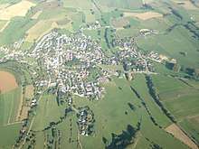
Aerial view of Garnich (Garnech)
See also
References
External links

Places adjacent to Garnich | |
|---|---|

This article is issued from
Wikipedia.
The text is licensed under Creative Commons - Attribution - Sharealike.
Additional terms may apply for the media files.