Garn Boduan
| Garn Boduan | |
|---|---|
| Highest point | |
| Elevation | 279 m (915 ft) |
| Prominence | 172 m (564 ft) |
| Listing | Marilyn |
| Geography | |
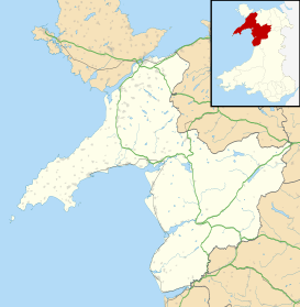
| Location | Llŷn Peninsula, Wales |
| Parent range | Snowdonia and Llyn Peninsula |
| Garn Boduan | |
|---|---|
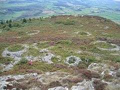 Stone hut circles on Garn Boduan | |
 Garn Boduan | |
| OS grid reference | SH311393 |
| Coordinates | 52°55′29″N 4°30′51″W / 52.9247°N 4.5141°WCoordinates: 52°55′29″N 4°30′51″W / 52.9247°N 4.5141°W |
Garn Boduan is an Iron Age hillfort and hill near Nefyn, on the Llŷn Peninsula in Wales.
In a survey in the 1950s the traces of over 170 round houses were identified on this site, and around 100 round houses are still visible on the ground.[1] Between 100 and 400 people may have lived in this fort.[2] The lower stone rampart is the original defence built in the Iron Age.[3] At a later date, perhaps in the 6th/7th century AD, a smaller rampart was built on the eastern side.[3]
See also
References
- ↑ Garn Boduan, Rhiw.com
- ↑ "Hillforts in Iron Age Wales". World Timelines. Archived from the original on 27 December 2010. Retrieved 29 November 2010.
- 1 2 Garn Boduan, BBC Wales
External links
| Wikimedia Commons has media related to Garn Boduan. |
- Garn Boduan, BBC Wales
- Garn Boduan, Rhiw.com
This article is issued from
Wikipedia.
The text is licensed under Creative Commons - Attribution - Sharealike.
Additional terms may apply for the media files.