Gare de Nonancourt
Gare de Nonancourt Gare de Nonancourt | |
|---|---|
| Railway Halt (Halte ferroviaire) | |
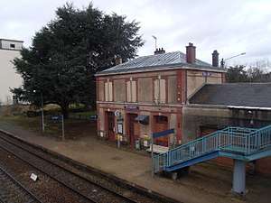 The passenger building from the footbridge | |
| Other names | Halte de Nonancourt |
| Location |
Place de la Gare 27320 NonancourtEure |
| Elevation | 139 m |
| Owned by | SNCF |
| Operated by | SNCF |
| Line(s) | Paris to Granville line, Saint-Cyr to Surdon line |
| Distance | Kilometric point 96,366 of the Saint-Cyr to Surdon line |
| Platforms | 2 |
| Tracks | 2 |
| Train operators | TER Normandie |
| Connections | none |
| Construction | |
| Parking | yes |
| Disabled access | none |
| History | |
| Opened | 1 October 1986 |
| Pre-nationalisation | Chemins de fer de l'Ouest |
Gare de Nonancourt is a railway station in France, owned and operated by the SNCF and is served by TER Normandie services. It is situated on the Saint-Cyr to Surdon line, serving the town of Nonancourt, in the Eure department of Normandy.
The location of the station is at a height of 139 m (456 ft) above sea level, at the kilometric point 96,366 of the Saint-Cyr to Surdon line, between the stations of Verneuil-sur-Avre and Dreux.
The station contains a passenger building, which is used as a waiting room for passengers. Tickets are not sold at the station (they need to be purchased in advance).
The station is equipped with two side platforms and two central tracks. The platform changes are made using a footbridge.
In 2018, the station is served by TER Normandie services between Paris-Montparnasse (or Dreux) and Argentan (or Granville), although there are no services to Paris-Montparnasse - Granville.[1]
Parking is available close to the station.[1]
History
The station was opened on 1 October 1986.
In 2015, the annual traffic is estimated around 25,390 commuters.[2]
Services
| Preceding station | SNCF | Following station | ||
|---|---|---|---|---|
toward Paris-Montparnasse | TER Normandie | toward Argentan |
||
Terminus | TER Normandie | toward Argentan |
||
Terminus | TER Normandie | toward Granville |
References
- 1 2 "Horaires et informations pratiques au départ de la gare Nonancourt". www.ter.sncf.com (in French). Retrieved 2018-05-05.
- ↑ "Fréquentation en gares". ressources.data.sncf.com (in French). Retrieved 2018-05-05.