Gambier (commune)
| French commune of Gambier | |
|---|---|
| Commune | |
 A ship from Gambier | |
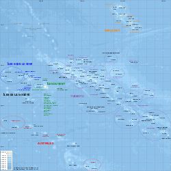 Location of Gambier in the Tuamotu Archipelago | |
| Coordinates: 23°08′S 134°56′W / 23.14°S 134.94°WCoordinates: 23°08′S 134°56′W / 23.14°S 134.94°W | |
| Country | France |
| Overseas collectivity | French Polynesia |
| Government | |
| • Mayor (2008–2014) | Monique Labbeyi-Richeton |
| Area | 61.63 km2 (23.80 sq mi) |
| Population (2016)1 | 1,564 |
| • Density | 25/km2 (66/sq mi) |
| INSEE/Postal code | 98719 /98755 |
| Elevation | 0–441 m (0–1,447 ft) |
| 1 Population without double counting: residents of multiple communes (e.g., students and military personnel) only counted once. | |
Gambier is a commune of French Polynesia in the archipelago of the Tuamotu Islands. The commune includes several groups of islands, which are located within a short distance from the Gambier Islands. The Acteon Group, and the nearby atolls of Maria Est, Morane, Marutea Sud and Temoe (23°20′46″S 134°28′28″W / 23.34611°S 134.47444°W), mostly uninhabited, and are sometimes mistakenly included among the Gambier Islands themselves. The chef-lieu of the commune is the island of Mangareva and the chief-town is Rikitea.
Administration
The commune of Gambier is made up of the Gambier Islands, uninhabited Temoe Atoll 40 km southeast of Mangareva, the uninhabited Acteon Group to the northwest (Matureivavao, Tenararo, Tenarunga, Vahanga), and the also uninhabited atolls of Maria Est and Morane, and finally, the pearl farm atoll of Marutea Sud. This group of islands and atolls covers an area of 32.06 km².
All of these archipelagos are administered as a single municipality (commune), with the main village of Rikitea, on the largest island of Mangareva.
The commune of Gambier comprises:
- Gambier Islands
- Mangareva Islands
- Temoe atoll : one main island and a dozen of motus separated by passes over the corall reef.
- Acteon Group made of four atolls Tenararo, Vahanga, Tenarunga, Matureivavao.
- isolated atoll of Marutea Sud.
- isolated atoll of Maria Est.
- isolated atoll of Morane.
The Gambier Islands (Gambier), together with the islands in the eastern part of the Tuamotus (Anaa, Fangatau, Hao, Hikueru, Makemo, Napuka, Nukutavake, Puka-Puka, Reao, Tatakoto and Tureia), form Îles Gambier et Tuamotu Est, one of the 6 electoral districts (circonscriptions électorales) for the Assembly of French Polynesia (Assemblée de la Polynésie française).
Together with the Tuamotus, the Gambier Islands form Îles Tuamotu-Gambier (French: (les) (Îles) Tuamotu-Gambier or officially la subdivision administrative des (Îles) Tuamotu-Gambier), one of the five primary administrative divisions (subdivisions administratives) of French Polynesia.
History
see Gambier Islands
See also
References
External links
| Wikimedia Commons has media related to Gambier. |